
Make a donation
Gear up for your next adventure:
As an Amazon Associate, this site earns from qualifying purchases at no extra cost to you.
Lares topographic map
Click on the map to display elevation.
Make a donation
Gear up for your next adventure:
As an Amazon Associate, this site earns from qualifying purchases at no extra cost to you.
About this map
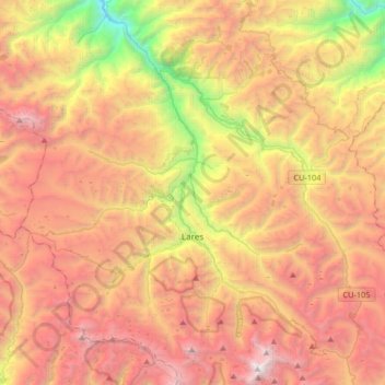
Name: Lares topographic map, elevation, terrain.
Location: Lares, Province of Calca, Cusco, Peru (-13.21499 -72.19120 -12.92083 -71.86179)
Average elevation: 3,944 m
Minimum elevation: 1,896 m
Maximum elevation: 5,744 m
Make a donation
Gear up for your next adventure:
As an Amazon Associate, this site earns from qualifying purchases at no extra cost to you.
Other topographic maps
Click on a map to view its topography, its elevation and its terrain.
Cuzco
Cusco is the seventh-most populous city in Peru; in 2017, it had a population of 428,450. It is also the largest city in the Peruvian Andes and the region is the seventh-most populous metropolitan area of Peru. Its elevation is around 3,400 m (11,200 ft). The largest district in the city is the Cusco District,…
Average elevation: 3,790 m
Machu Picchu
Peru > Cusco > Machupicchu > San Miguel
Animals are also suspected to have immigrated to Machu Picchu as there were several bones found that were not native to the area. Most animal bones found were from llamas and alpacas. These animals naturally live at altitudes of 4,000 metres (13,000 ft) rather than the 2,400 metres (7,900 ft) elevation of…
Average elevation: 2,227 m
Vinicunca
Vinicunca, or Winikunka, also called Montaña de Siete Colores (literally: Mountain of seven colors), Montaña de Colores (Mountain of colors) or Montaña Arcoíris (Rainbow Mountain), is a mountain in the Andes of Peru with an altitude of 5,200 metres (17,100 ft) above sea level. It is located on the road to…
Average elevation: 4,874 m
Make a donation
Gear up for your next adventure:
As an Amazon Associate, this site earns from qualifying purchases at no extra cost to you.
Sacsayhuamán
Peru > Cusco > Cuzco > Mollococha
Sacsayhuamán (/ˈsæksaɪˌwʌmən/ SACK-sy-wuh-mən; Spanish pronunciation: [saksajwaˈman]) or Saksaywaman (from Quechua Saksay waman pukara, pronounced [ˈsaksaj ˈwaman], lit. 'fortress of the royal falcon or hawk') is a citadel on the northern outskirts of the city of Cusco, Peru, the historic capital…
Average elevation: 3,578 m
Make a donation
Gear up for your next adventure:
As an Amazon Associate, this site earns from qualifying purchases at no extra cost to you.
Cuzco
Cusco is the seventh-most populous city in Peru; in 2017, it had a population of 428,450. It is also the largest city in the Peruvian Andes and the region is the seventh-most populous metropolitan area of Peru. Its elevation is around 3,400 m (11,200 ft). The largest district in the city is the Cusco District,…
Average elevation: 3,790 m
Make a donation
Gear up for your next adventure:
As an Amazon Associate, this site earns from qualifying purchases at no extra cost to you.
Quelccaya
The Andes in Peru, Ecuador, and Bolivia are subdivided into several separate mountain ranges, many of which are glaciated above 5,000 metres (16,000 ft) elevation; Peru contains about 70% of all tropical glaciers. Together with the Coropuna volcano also in southern Peru and ice bodies in New Guinea and the…
Average elevation: 5,167 m
Make a donation
Gear up for your next adventure:
As an Amazon Associate, this site earns from qualifying purchases at no extra cost to you.
Cuzco
Cusco is the seventh-most populous city in Peru; in 2017, it had a population of 428,450. It is also the largest city in the Peruvian Andes and the region is the seventh-most populous metropolitan area of Peru. Its elevation is around 3,400 m (11,200 ft). The largest district in the city is the Cusco District,…
Average elevation: 3,790 m
Make a donation
Gear up for your next adventure:
As an Amazon Associate, this site earns from qualifying purchases at no extra cost to you.
Make a donation
Gear up for your next adventure:
As an Amazon Associate, this site earns from qualifying purchases at no extra cost to you.
Vinicunca
Vinicunca, or Winikunka, also called Montaña de Siete Colores (literally: Mountain of seven colors), Montaña de Colores (Mountain of colors) or Montaña Arcoíris (Rainbow Mountain), is a mountain in the Andes of Peru with an altitude of 5,036 metres (16,522 ft) above sea level. It is located on the road to…
Average elevation: 4,874 m
Make a donation
Gear up for your next adventure:
As an Amazon Associate, this site earns from qualifying purchases at no extra cost to you.
Make a donation
Gear up for your next adventure:
As an Amazon Associate, this site earns from qualifying purchases at no extra cost to you.
Nevado Salkantay
Salcantay, Salkantay or Sallqantay (in Quechua) is the highest peak in the Vilcabamba mountain range, part of the Peruvian Andes. It is located in the Cusco Region, about 60 km (40 mi) west-northwest of the city of Cusco. It is the 38th-highest peak in the Andes and the twelfth-highest in Peru. However, as a…
Average elevation: 5,266 m
Make a donation
Gear up for your next adventure:
As an Amazon Associate, this site earns from qualifying purchases at no extra cost to you.
Cuzco
Cusco or Cuzco (Latin American Spanish: [ˈkusko]; Quechua: Qosqo or Qusqu, both pronounced [ˈqosqɔ]) is a city in southeastern Peru, near the Sacred Valley of the Andes mountain range and the Huatanay river. It is the capital of the eponymous province and department. The city is the seventh most populous in…
Average elevation: 3,790 m
Make a donation
Gear up for your next adventure:
As an Amazon Associate, this site earns from qualifying purchases at no extra cost to you.
Make a donation
Gear up for your next adventure:
As an Amazon Associate, this site earns from qualifying purchases at no extra cost to you.
Make a donation
Gear up for your next adventure:
As an Amazon Associate, this site earns from qualifying purchases at no extra cost to you.
Make a donation
Gear up for your next adventure:
As an Amazon Associate, this site earns from qualifying purchases at no extra cost to you.
Make a donation
Gear up for your next adventure:
As an Amazon Associate, this site earns from qualifying purchases at no extra cost to you.