
Make a donation
Gear up for your next adventure:
As an Amazon Associate, this site earns from qualifying purchases at no extra cost to you.
Gemeinde Guntramsdorf topographic map
Click on the map to display elevation.
Make a donation
Gear up for your next adventure:
As an Amazon Associate, this site earns from qualifying purchases at no extra cost to you.
About this map
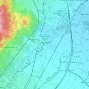
Name: Gemeinde Guntramsdorf topographic map, elevation, terrain.
Average elevation: 205 m
Minimum elevation: 173 m
Maximum elevation: 384 m
Make a donation
Gear up for your next adventure:
As an Amazon Associate, this site earns from qualifying purchases at no extra cost to you.
Other topographic maps
Click on a map to view its topography, its elevation and its terrain.
Perchtoldsdorfer Heide
Austria > Lower Austria > Bezirk Mödling > Perchtoldsdorf
Average elevation: 312 m
Vorderer Kaufberg
Austria > Lower Austria > Bezirk Mödling > Gemeinde Breitenfurt bei Wien
Average elevation: 341 m
Sulz im Wienerwald
Austria > Lower Austria > Bezirk Mödling > Gemeinde Wienerwald
Average elevation: 459 m