
Lac Le Jeune topographic map
Interactive map
Click on the map to display elevation.
About this map
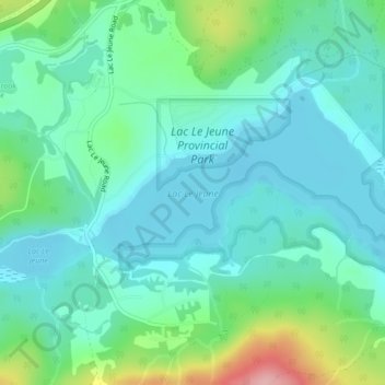
Name: Lac Le Jeune topographic map, elevation, terrain.
Average elevation: 1,309 m
Minimum elevation: 1,272 m
Maximum elevation: 1,431 m
Other topographic maps
Click on a map to view its topography, its elevation and its terrain.
Isobel Lake
Canada > British Columbia > Thompson-Nicola Regional District > Area J (Copper Desert Country)
Isobel Lake, Area J (Copper Desert Country), Thompson-Nicola Regional District, British Columbia, Canada
Average elevation: 1,058 m
Red Lake
Canada > British Columbia > Thompson-Nicola Regional District > Area J (Copper Desert Country)
Red Lake, Area J (Copper Desert Country), Thompson-Nicola Regional District, British Columbia, Canada
Average elevation: 1,036 m
Cultus Lake
Canada > British Columbia > Thompson-Nicola Regional District > Area J (Copper Desert Country)
Cultus Lake, Area J (Copper Desert Country), Thompson-Nicola Regional District, British Columbia, Canada
Average elevation: 1,033 m
Tunkwa Lake
Canada > British Columbia > Thompson-Nicola Regional District > Area J (Copper Desert Country)
Tunkwa Lake, Area J (Copper Desert Country), Thompson-Nicola Regional District, British Columbia, Canada
Average elevation: 1,161 m
Kamloops Lake
Canada > British Columbia > Thompson-Nicola Regional District > Area J (Copper Desert Country)
Kamloops Lake, Area J (Copper Desert Country), Thompson-Nicola Regional District, British Columbia, V0K 2J0, Canada
Average elevation: 975 m
Lac Le Jeune Provincial Park
Canada > British Columbia > Thompson-Nicola Regional District > Area J (Copper Desert Country)
Lac Le Jeune Provincial Park, Area J (Copper Desert Country), Thompson-Nicola Regional District, British Columbia, Canada
Average elevation: 1,308 m
Skeetchestn Indian Band
Canada > British Columbia > Thompson-Nicola Regional District > Area J (Copper Desert Country)
Skeetchestn Indian Band, Area J (Copper Desert Country), Thompson-Nicola Regional District, British Columbia, V0K 2P0, Canada
Average elevation: 1,091 m
Edith Lake
Canada > British Columbia > Thompson-Nicola Regional District > Area J (Copper Desert Country)
Edith Lake, Area J (Copper Desert Country), Thompson-Nicola Regional District, British Columbia, Canada
Average elevation: 1,054 m
Sparks Lake
Canada > British Columbia > Thompson-Nicola Regional District > Area J (Copper Desert Country)
Sparks Lake, Area J (Copper Desert Country), Thompson-Nicola Regional District, British Columbia, Canada
Average elevation: 1,016 m
McConnell Lake Provincial Park
Canada > British Columbia > Thompson-Nicola Regional District > Area J (Copper Desert Country)
McConnell Lake Provincial Park, McConnell Lake Provincial Pk, Area J (Copper Desert Country), Thompson-Nicola Regional District, British Columbia, Canada
Average elevation: 1,329 m
Hoodoos
Canada > British Columbia > Thompson-Nicola Regional District > Area J (Copper Desert Country)
Hoodoos, Balancing Rock and Hoodoos Trail, Area J (Copper Desert Country), Thompson-Nicola Regional District, British Columbia, Canada
Average elevation: 469 m
Face Lake
Canada > British Columbia > Thompson-Nicola Regional District > Area J (Copper Desert Country)
Face Lake, Area J (Copper Desert Country), Thompson-Nicola Regional District, British Columbia, Canada
Average elevation: 1,516 m
Pass Lake
Canada > British Columbia > Thompson-Nicola Regional District > Area J (Copper Desert Country)
Pass Lake, Area J (Copper Desert Country), Thompson-Nicola Regional District, British Columbia, Canada
Average elevation: 1,117 m
Savona
Canada > British Columbia > Thompson-Nicola Regional District > Area J (Copper Desert Country) > Savona
Savona, Area J (Copper Desert Country), Thompson-Nicola Regional District, British Columbia, Canada
Average elevation: 480 m
Tobiano
Canada > British Columbia > Thompson-Nicola Regional District > Area J (Copper Desert Country)
Tobiano, Area J (Copper Desert Country), Thompson-Nicola Regional District, British Columbia, Canada
Average elevation: 430 m