
Ross County topographic map
Interactive map
Click on the map to display elevation.
About this map
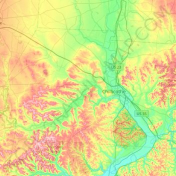
Name: Ross County topographic map, elevation, terrain.
Location: Ross County, Ohio, Verenigde Staten van Amerika (39.16781 -83.39437 39.51597 -82.74069)
Average elevation: 257 m
Minimum elevation: 165 m
Maximum elevation: 409 m
Other topographic maps
Click on a map to view its topography, its elevation and its terrain.
Norwood
Verenigde Staten van Amerika > Ohio > Norwood
Norwood, Hamilton County, Ohio, Verenigde Staten van Amerika
Average elevation: 196 m
Mason
Verenigde Staten van Amerika > Ohio > Mason
Mason, Warren County, Ohio, 45040, Verenigde Staten van Amerika
Average elevation: 248 m