
Make a donation
Gear up for your next adventure:
As an Amazon Associate, this site earns from qualifying purchases at no extra cost to you.
Donokerto topographic map
Click on the map to display elevation.
Make a donation
Gear up for your next adventure:
As an Amazon Associate, this site earns from qualifying purchases at no extra cost to you.
About this map
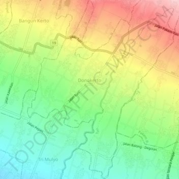
Name: Donokerto topographic map, elevation, terrain.
Average elevation: 370 m
Minimum elevation: 278 m
Maximum elevation: 490 m
Make a donation
Gear up for your next adventure:
As an Amazon Associate, this site earns from qualifying purchases at no extra cost to you.
Other topographic maps
Click on a map to view its topography, its elevation and its terrain.
Wisdom park
Indonesia > Special Region of Yogyakarta > Sleman Regency > Catur tunggal
Average elevation: 136 m
taman sari
Indonesia > Special Region of Yogyakarta > Sleman Regency > Sinduharjo
Average elevation: 173 m
Pakem Binangun
Indonesia > Special Region of Yogyakarta > Sleman Regency > Pakembinangun
Average elevation: 448 m
Make a donation
Gear up for your next adventure:
As an Amazon Associate, this site earns from qualifying purchases at no extra cost to you.
SUNGAI OPAK
Indonesia > Special Region of Yogyakarta > Sleman Regency > Leses
Average elevation: 236 m
Ngipiksari
Indonesia > Special Region of Yogyakarta > Sleman Regency > Hargobinangun > Kaliurang
Average elevation: 794 m
Cangkringan
Indonesia > Special Region of Yogyakarta > Sleman Regency > Argomulyo
Average elevation: 453 m
Kalasan
Indonesia > Special Region of Yogyakarta > Sleman Regency > Tirtomartani
Average elevation: 143 m
Make a donation
Gear up for your next adventure:
As an Amazon Associate, this site earns from qualifying purchases at no extra cost to you.
Minggir
Indonesia > Special Region of Yogyakarta > Sleman Regency > Sendangagung
Average elevation: 142 m
Margoagung
Indonesia > Special Region of Yogyakarta > Sleman Regency > Margoagung
Average elevation: 194 m
Sungai Code
Indonesia > Special Region of Yogyakarta > Sleman Regency > Yogyakarta
Average elevation: 110 m
Kemiri Kebo
Indonesia > Special Region of Yogyakarta > Sleman Regency > Girikerto
Average elevation: 713 m
Make a donation
Gear up for your next adventure:
As an Amazon Associate, this site earns from qualifying purchases at no extra cost to you.
Margo Rejo
Indonesia > Special Region of Yogyakarta > Sleman Regency > Margorejo
Average elevation: 304 m
Lumbung Rejo
Indonesia > Special Region of Yogyakarta > Sleman Regency > Lumbungrejo
Average elevation: 338 m
Tempel
Indonesia > Special Region of Yogyakarta > Sleman Regency > Lumbungrejo
Average elevation: 323 m
Tlogo Putri Kaliurang
Indonesia > Special Region of Yogyakarta > Sleman Regency > Hargobinangun > Kaliurang
Average elevation: 948 m
Make a donation
Gear up for your next adventure:
As an Amazon Associate, this site earns from qualifying purchases at no extra cost to you.
Sumber Rejo
Indonesia > Special Region of Yogyakarta > Sleman Regency > Sumberrejo
Average elevation: 233 m
Jogotirto
Indonesia > Special Region of Yogyakarta > Sleman Regency > Jogotirto
Average elevation: 96 m
Kaliurang
Indonesia > Special Region of Yogyakarta > Sleman Regency > Hargobinangun
Average elevation: 858 m
Embung Tambakboyo
Indonesia > Special Region of Yogyakarta > Sleman Regency > Condongcatur > Condong Catur
Average elevation: 164 m
Make a donation
Gear up for your next adventure:
As an Amazon Associate, this site earns from qualifying purchases at no extra cost to you.
Bangun Kerto
Indonesia > Special Region of Yogyakarta > Sleman Regency > Bangunkerto
Average elevation: 379 m