Geolocate
👉 Easily get elevation data in JSON, GeoTIFF and KML formats using Elevation API
Thank you for supporting this site ❤️
Make a donation

Frisco topographic map

Click on the map to display elevation.

👉 Easily get elevation data in JSON, GeoTIFF and KML formats using Elevation API
Thank you for supporting this site ❤️
Make a donation

About this map

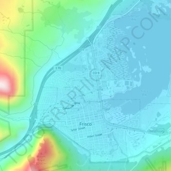
Name: Frisco topographic map, elevation, terrain.

Location: Frisco, Summit County, Colorado, United States (39.56718 -106.11404 39.59869 -106.06492)

Average elevation: 2,835 m

Minimum elevation: 2,748 m

Maximum elevation: 3,291 m

Other topographic maps

Click on a map to view its topography, its elevation and its terrain.

Argentine Pass

United States > Colorado > Summit County

Argentine Pass, elevation 13,207 ft (4,025 m), is a high mountain pass that crosses the Continental Divide in the Front Range of the Rocky Mountains of central Colorado in the United States. Argentine Pass is located on the crest of the Front Range along the boundary southwest of Georgetown and is the highest…

Average elevation: 3,797 m

Mount Guyot

United States > Colorado > Summit County

Average elevation: 3,601 m

Quandary Peak

United States > Colorado > Summit County

Quandary Peak is the highest summit of the Tenmile Range in the Rocky Mountains of North America at 14,271 ft (4,350 m). As of 2018, it was the most commonly climbed fourteener in Colorado. It has nearly the same elevation as Castle Peak and Mount Blue Sky. It lies in Summit County and within the White River…

Average elevation: 3,833 m

Chief Mountain

United States > Colorado > Summit County

Average elevation: 3,367 m

Silverthorne

United States > Colorado > Summit County

Average elevation: 2,858 m

Dillon

United States > Colorado > Summit County > Silverthorne

Average elevation: 2,796 m

Decatur Mountain

United States > Colorado > Summit County

Average elevation: 3,661 m

Bald Mountain

United States > Colorado > Summit County

Average elevation: 3,733 m

Gear up for your next adventure:

🛶Inflatable Touring Kayaks - Explore Irish loughs and coastal topography
🧴Anti-Chafe Sticks - Prevent friction during long distance walking
📈Fitness Trackers - Monitor activity and hike metrics
📡Satellite Messengers - Emergency communication for remote areas without signal
Ultralight Hiking Tents - Compact shelters for multi-day wild camping in Ireland

As an Amazon Associate, this site earns from qualifying purchases at no extra cost to you.