
Purba Medinipur District topographic map
Interactive map
Click on the map to display elevation.
About this map
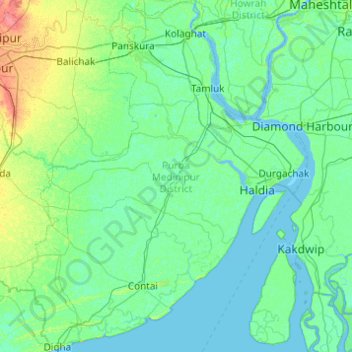
Name: Purba Medinipur District topographic map, elevation, terrain.
Location: Purba Medinipur District, West Bengal, India (21.60977 87.42161 22.51598 88.20416)
Average elevation: 6 m
Minimum elevation: -2 m
Maximum elevation: 43 m
Purba Medinipur district is part of the lower Indo-Gangetic Plain and Eastern coastal plains. Topographically, the district can be divided into two parts – (a) almost entirely flat plains on the west, east and north, (b) the coastal plains on the south. The vast expanse of land is formed of alluvium and is composed of younger and coastal alluvial. The elevation of the district is within 10 meters above the mean sea level. The district has a long coastline of 65.5 km along its southern and south eastern boundary. Five coastal CD Blocks, namely, Khejuri II, Contai II (Deshapran), Contai I, Ramnagar I and II, are occasionally affected by cyclones and tornadoes. Tidal floods are quite regular in these five CD Blocks. Normally floods occur in 21 of the 25 CD Blocks in the district. The major rivers are Haldi, Rupnarayan, Rasulpur, Bagui and Keleghai, flowing in north to south or south-east direction. River water is an important source of irrigation. The district has a low 899 hectare forest cover, which is 0.02% of its geographical area.
Other topographic maps
Click on a map to view its topography, its elevation and its terrain.
Kolkata
Kolkata, Kolkata District, West Bengal, 700073, India
Average elevation: 5 m
Kakdwip
India > West Bengal > Kakdwip
Kakdwip, South 24 Parganas District, West Bengal, 743347, India
Average elevation: 3 m
Raina - I
Raina - I, Purba Bardhaman District, West Bengal, India
Average elevation: 28 m
B-17
India > West Bengal > Kalyani
B-17, Kalyani, Nadia District, West Bengal, India
Average elevation: 10 m
Sillery Gaon
India > West Bengal > Kalimpong - II
Sillery Gaon, Kalimpong - II, Kalimpong District, West Bengal, 734311, India
Average elevation: 1,549 m
Kestopur Khal
India > West Bengal > Bhangar - II > Bidhannagar
Kestopur Khal, Bidhannagar, Bhangar - II, South 24 Parganas District, West Bengal, India
Average elevation: 4 m
Kalimpong -I
Kalimpong -I, Kalimpong District, West Bengal, India
Average elevation: 824 m
New Barrackpore
India > West Bengal > Barrackpore
New Barrackpore, Barrackpore, North 24 Parganas District, West Bengal, 700131, India
Average elevation: 6 m
Sonada
India > West Bengal > Jorebunglow Sukiapokhri
Sonada, Jorebunglow Sukiapokhri, Darjeeling District, West Bengal, 734102, India
Average elevation: 1,797 m
Todey
India > West Bengal > Gorubathan
Todey, Gorubathan, Kalimpong District, West Bengal, India
Average elevation: 1,325 m
Jorebunglow Sukiapokhri
Jorebunglow Sukiapokhri, Darjeeling District, West Bengal, India
Average elevation: 1,591 m
Kurseong
India > West Bengal > Kurseong Subdivision
Kurseong, Kurseong Subdivision, Darjeeling District, West Bengal, 734203, India
Average elevation: 1,127 m
Thakurpukur Maheshtala
Thakurpukur Maheshtala, South 24 Parganas District, West Bengal, India
Average elevation: 5 m
Magrahat - I
Magrahat - I, South 24 Parganas District, West Bengal, India
Average elevation: 4 m
Alipore Zoo
India > West Bengal > Kolkata
Alipore Zoo, Alipore, Kolkata, Kolkata District, West Bengal, India
Average elevation: 9 m
Alipurduar - II
Alipurduar - II, Alipurduar District, West Bengal, India
Average elevation: 57 m
Mahadipur
India > West Bengal > English Bazar
Mahadipur, English Bazar, Maldah District, West Bengal, 732216, India
Average elevation: 25 m
Madaripur
India > West Bengal > Islampur
Madaripur, Islampur, Uttar Dinajpur District, West Bengal, India
Average elevation: 69 m
Maynaguri
India > West Bengal > Maynaguri
Maynaguri, Jalpaiguri District, West Bengal, 735224, India
Average elevation: 83 m
Uttar Dinajpur District
Uttar Dinajpur District, West Bengal, India
Average elevation: 45 m
Odlabari
India > West Bengal > Mal
Odlabari, Mal, Jalpaiguri District, West Bengal, 735222, India
Average elevation: 168 m
Chalsa
India > West Bengal > Matiali
Chalsa, Matiali, Jalpaiguri District, West Bengal, 735206, India
Average elevation: 185 m
Deganga
Deganga, North 24 Parganas District, West Bengal, India
Average elevation: 5 m
Jaigaon
India > West Bengal > Kalchini
Jaigaon, Kalchini, Alipurduar District, West Bengal, 735182, India
Average elevation: 316 m
Tamluk
India > West Bengal > Tamluk
Tamluk, Purba Medinipur District, West Bengal, 721600, India
Average elevation: 3 m
Jamalpur
Jamalpur, Purba Bardhaman District, West Bengal, India
Average elevation: 19 m
Jalpaiguri District
Jalpaiguri District, West Bengal, India
Average elevation: 170 m
Kranti
India > West Bengal > Mal
Kranti, Mal, Jalpaiguri District, West Bengal, 735218, India
Average elevation: 100 m
Bhangar - I
Bhangar - I, South 24 Parganas District, West Bengal, 743502, India
Average elevation: 3 m
Raninagar - II
Raninagar - II, Murshidabad District, West Bengal, 742308, India
Average elevation: 18 m
Belpahari
India > West Bengal > Binpur-II
Belpahari, Binpur-II, Jhargram District, West Bengal, India
Average elevation: 140 m
Kolaghat
India > West Bengal > Kolaghat
Kolaghat, Purba Medinipur District, West Bengal, 721134, India
Average elevation: 4 m
Jagatballavpur
Jagatballavpur, Howrah District, West Bengal, India
Average elevation: 5 m
Amdanga
India > West Bengal > Amdanga
Amdanga, North 24 Parganas District, West Bengal, 743221, India
Average elevation: 7 m
Bankura
India > West Bengal > Bankura - I
Bankura, Bankura - I, Bankura District, West Bengal, 722101, India
Average elevation: 103 m
Narayanpur,purba bardhaman,713127
India > West Bengal > Bhatar
Narayanpur,purba bardhaman,713127, Bhatar, Purba Bardhaman District, West Bengal, 713127, India
Average elevation: 36 m
Maldah (Old)
Maldah (Old), Maldah District, West Bengal, India
Average elevation: 27 m
West Dinājpur
West Dinājpur, Dakshin Dinajpur District, West Bengal, India
Average elevation: 34 m
Ghuni
Ghuni, North 24 Parganas District, West Bengal, 700161, India
Average elevation: 3 m
Mathabhanga - I
Mathabhanga - I, Cooch Behar District, West Bengal, India
Average elevation: 54 m
Shantipur
India > West Bengal > Santipur
Shantipur, Santipur, Nadia District, West Bengal, 741404, India
Average elevation: 11 m
Patrasayer
Patrasayer, Bankura District, West Bengal, 722206, India
Average elevation: 52 m
Rajpur Sonarpur
India > West Bengal > Sonarpur
Rajpur Sonarpur, Sonarpur, South 24 Parganas District, West Bengal, 700150, India
Average elevation: 4 m
Matla
India > West Bengal > Canning - II
Matla, Canning - II, South 24 Parganas, West Bengal, 743329, India
Average elevation: 3 m
Chandannagar
India > West Bengal > Singur
Chandannagar, Singur, Hugli, West Bengal, 712136, India
Average elevation: 8 m