
Make a donation
Gear up for your next adventure:
As an Amazon Associate, this site earns from qualifying purchases at no extra cost to you.
Palma topographic map
Click on the map to display elevation.
Make a donation
Gear up for your next adventure:
As an Amazon Associate, this site earns from qualifying purchases at no extra cost to you.
Palma
Palma is a major city and seaport located in the southwest of Mallorca, a western Mediterranean island belonging to the Balearic Islands archipelago. The land area of the city is about 21.355 square kilometres (8.245 sq mi) with an altitude of 13 metres (43 feet) above sea level.
Make a donation
Gear up for your next adventure:
As an Amazon Associate, this site earns from qualifying purchases at no extra cost to you.
About this map
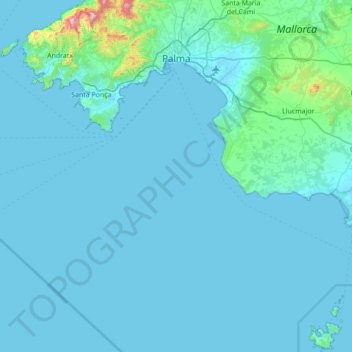
Name: Palma topographic map, elevation, terrain.
Location: Palma, Balearic Islands, Spain (39.12073 2.56385 39.65826 2.97986)
Average elevation: 45 m
Minimum elevation: -1 m
Maximum elevation: 955 m
Make a donation
Gear up for your next adventure:
As an Amazon Associate, this site earns from qualifying purchases at no extra cost to you.
Other topographic maps
Click on a map to view its topography, its elevation and its terrain.