
Make a donation
Gear up for your next adventure:
As an Amazon Associate, this site earns from qualifying purchases at no extra cost to you.
Nestani topographic map
Click on the map to display elevation.
Make a donation
Gear up for your next adventure:
As an Amazon Associate, this site earns from qualifying purchases at no extra cost to you.
Nestani
It is situated at the foot of the mountain Artemisio, at about 700 m elevation. It was the seat of the former municipality Mantineia. The community Nestani also contains the village of Milea. Nestani is 11 km east of Kapsas, 13 km southwest of Lyrkeia (Argolis) and 14 km northeast of Tripoli. The Moreas Motorway (Corinth–Tripoli-Kalamata/Sparta) passes west of the village.
Make a donation
Gear up for your next adventure:
As an Amazon Associate, this site earns from qualifying purchases at no extra cost to you.
About this map
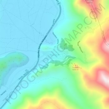
Name: Nestani topographic map, elevation, terrain.
Average elevation: 827 m
Minimum elevation: 623 m
Maximum elevation: 1,422 m
Make a donation
Gear up for your next adventure:
As an Amazon Associate, this site earns from qualifying purchases at no extra cost to you.