
南昌市 topographic map
Interactive map
Click on the map to display elevation.
About this map
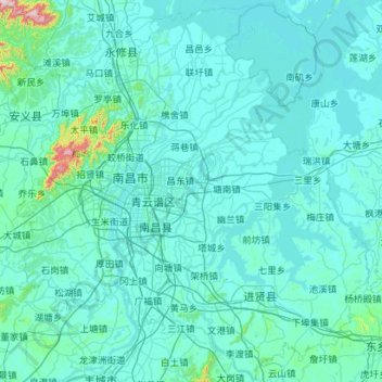
Name: 南昌市 topographic map, elevation, terrain.
Location: 南昌市, 江西省, 中国 (28.16067 115.43426 29.13692 116.56084)
Average elevation: 42 m
Minimum elevation: 7 m
Maximum elevation: 932 m
江西省周边均为山地,境内多为丘陵,唯独赣北一处由于赣江、抚河、信江、鄱江、修水从四方汇聚与此注入鄱阳湖,所以形成鄱阳湖平原。南昌市就位于豫章平原中部,赣江之畔。南昌具有“西山东水”的自然地势,市区西北部有一座孤立的西山山脉——梅岭,呈西南东北走向,主峰洗药峰海拔841.1米,是全市的最高点。在全市土地面积构成中,平原占35.8%,水域占29.8%,岗地、低丘占34.4%。
Other topographic maps
Click on a map to view its topography, its elevation and its terrain.