
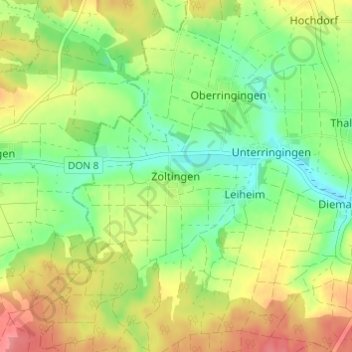
Zoltingen topographic map
Interactive map
Click on the map to display elevation.
About this map
Name: Zoltingen topographic map, elevation, terrain.
Average elevation: 510 m
Minimum elevation: 475 m
Maximum elevation: 553 m
Other topographic maps
Click on a map to view its topography, its elevation and its terrain.
89423
Deutschland > Bayern > Landkreis Dillingen an der Donau > Gundelfingen a.d.Donau
89423, Peterswörth, Gundelfingen a.d.Donau, Gundelfingen an der Donau (VGem), Landkreis Dillingen an der Donau, Bayern, Deutschland
Average elevation: 433 m
Lauingen (Donau)
Deutschland > Bayern > Landkreis Dillingen an der Donau
Lauingen (Donau), Landkreis Dillingen an der Donau, Bayern, 89415, Deutschland
Average elevation: 434 m
Binswangen
Deutschland > Bayern > Landkreis Dillingen an der Donau
Binswangen, Wertingen, Landkreis Dillingen an der Donau, Bayern, Deutschland
Average elevation: 429 m
86502
Deutschland > Bayern > Landkreis Dillingen an der Donau > Osterbuch
86502, Osterbuch, Laugna, Wertingen, Landkreis Dillingen an der Donau, Bayern, Deutschland
Average elevation: 476 m
Kicklingen
Deutschland > Bayern > Landkreis Dillingen an der Donau > Dillingen a.d.Donau
Kicklingen, Dillingen a.d.Donau, Landkreis Dillingen an der Donau, Bayern, 89407, Deutschland
Average elevation: 418 m
Zöschlingsweiler
Deutschland > Bayern > Landkreis Dillingen an der Donau
Zöschlingsweiler, Wittislingen, Wittislingen (VGem), Landkreis Dillingen an der Donau, Bayern, 89426, Deutschland
Average elevation: 440 m
Mörslingen
Deutschland > Bayern > Landkreis Dillingen an der Donau
Mörslingen, Finningen, Höchstädt an der Donau (VGem), Landkreis Dillingen an der Donau, Bayern, 89435, Deutschland
Average elevation: 435 m
Bissingen
Deutschland > Bayern > Landkreis Dillingen an der Donau
Bissingen, Landkreis Dillingen an der Donau, Bayern, 86657, Deutschland
Average elevation: 486 m
Wortelstetten
Deutschland > Bayern > Landkreis Dillingen an der Donau
Wortelstetten, Buttenwiesen, Landkreis Dillingen an der Donau, Bayern, 86647, Deutschland
Average elevation: 454 m
Dillingen a.d.Donau
Deutschland > Bayern > Landkreis Dillingen an der Donau
Dillingen a.d.Donau, Landkreis Dillingen an der Donau, Bayern, 89407, Deutschland
Average elevation: 430 m
Schwenningen
Deutschland > Bayern > Landkreis Dillingen an der Donau
Schwenningen, Höchstädt an der Donau (VGem), Landkreis Dillingen an der Donau, Bayern, 89443, Deutschland
Average elevation: 425 m
Oberthürheim
Deutschland > Bayern > Landkreis Dillingen an der Donau
Oberthürheim, Buttenwiesen, Landkreis Dillingen an der Donau, Bayern, 86647, Deutschland
Average elevation: 430 m
Laugna
Deutschland > Bayern > Landkreis Dillingen an der Donau
Laugna, Wertingen, Landkreis Dillingen an der Donau, Bayern, 86502, Deutschland
Average elevation: 470 m
Bächingen a.d.Brenz
Deutschland > Bayern > Landkreis Dillingen an der Donau
Bächingen a.d.Brenz, Gundelfingen an der Donau (VGem), Landkreis Dillingen an der Donau, Bayern, 89431, Deutschland
Average elevation: 442 m
Glött
Deutschland > Bayern > Landkreis Dillingen an der Donau
Glött, Holzheim, Landkreis Dillingen an der Donau, Bayern, 89353, Deutschland
Average elevation: 455 m
Aislingen
Deutschland > Bayern > Landkreis Dillingen an der Donau
Aislingen, Holzheim, Landkreis Dillingen an der Donau, Bayern, 89344, Deutschland
Average elevation: 452 m
Bergheim
Deutschland > Bayern > Landkreis Dillingen an der Donau
Bergheim, Mödingen, Wittislingen (VGem), Landkreis Dillingen an der Donau, Bayern, 89426, Deutschland
Average elevation: 448 m
Baumgarten
Deutschland > Bayern > Landkreis Dillingen an der Donau
Baumgarten, Aislingen, Holzheim, Landkreis Dillingen an der Donau, Bayern, 89344, Deutschland
Average elevation: 490 m
Leitenhof
Deutschland > Bayern > Landkreis Dillingen an der Donau > Bissingen
Leitenhof, Bissingen, Landkreis Dillingen an der Donau, Bayern, 86657, Deutschland
Average elevation: 499 m
Schabringen
Deutschland > Bayern > Landkreis Dillingen an der Donau
Schabringen, Wittislingen, Wittislingen (VGem), Landkreis Dillingen an der Donau, Bayern, 89426, Deutschland
Average elevation: 436 m
Osterbuch
Deutschland > Bayern > Landkreis Dillingen an der Donau
Osterbuch, Laugna, Wertingen, Landkreis Dillingen an der Donau, Bayern, 86502, Deutschland
Average elevation: 481 m
Wertingen
Deutschland > Bayern > Landkreis Dillingen an der Donau
Wertingen, Landkreis Dillingen an der Donau, Bayern, 86637, Deutschland
Average elevation: 445 m
Eppisburg
Deutschland > Bayern > Landkreis Dillingen an der Donau
Eppisburg, Holzheim, Landkreis Dillingen an der Donau, Bayern, 89438, Deutschland
Average elevation: 452 m
Holzheim
Deutschland > Bayern > Landkreis Dillingen an der Donau
Holzheim, Landkreis Dillingen an der Donau, Bayern, 89438, Deutschland
Average elevation: 460 m
Fristingen
Deutschland > Bayern > Landkreis Dillingen an der Donau > Dillingen a.d.Donau > Fristingen
Fristingen, Dillingen a.d.Donau, Landkreis Dillingen an der Donau, Bayern, 89407, Deutschland
Average elevation: 420 m
Gundelfingen an der Donau (VGem)
Deutschland > Bayern > Landkreis Dillingen an der Donau
Gundelfingen an der Donau (VGem), Landkreis Dillingen an der Donau, Bayern, Deutschland
Average elevation: 452 m
Ballhausen
Deutschland > Bayern > Landkreis Dillingen an der Donau
Ballhausen, Syrgenstein, Syrgenstein (VGem), Landkreis Dillingen an der Donau, Bayern, 89428, Deutschland
Average elevation: 511 m
Buttenwiesen
Deutschland > Bayern > Landkreis Dillingen an der Donau
Buttenwiesen, Landkreis Dillingen an der Donau, Bayern, 86647, Deutschland
Average elevation: 426 m
Lutzingen
Deutschland > Bayern > Landkreis Dillingen an der Donau
Lutzingen, Höchstädt an der Donau (VGem), Landkreis Dillingen an der Donau, Bayern, 89440, Deutschland
Average elevation: 477 m
Blindheim
Deutschland > Bayern > Landkreis Dillingen an der Donau
Blindheim, Höchstädt an der Donau (VGem), Landkreis Dillingen an der Donau, Bayern, 89434, Deutschland
Average elevation: 434 m
Gundelfingen a.d.Donau
Deutschland > Bayern > Landkreis Dillingen an der Donau
Gundelfingen a.d.Donau, Gundelfingen an der Donau (VGem), Landkreis Dillingen an der Donau, Bayern, 89423, Deutschland
Average elevation: 442 m
86647
Deutschland > Bayern > Landkreis Dillingen an der Donau > Pfaffenhofen an der Zusam
86647, Pfaffenhofen an der Zusam, Buttenwiesen, Landkreis Dillingen an der Donau, Bayern, Deutschland
Average elevation: 417 m
Syrgenstein
Deutschland > Bayern > Landkreis Dillingen an der Donau
Syrgenstein, Syrgenstein (VGem), Landkreis Dillingen an der Donau, Bayern, 89428, Deutschland
Average elevation: 522 m
Höchstädt an der Donau
Deutschland > Bayern > Landkreis Dillingen an der Donau
Höchstädt an der Donau, Höchstädt an der Donau (VGem), Landkreis Dillingen an der Donau, Bayern, 89420, Deutschland
Average elevation: 440 m
Zöschingen
Deutschland > Bayern > Landkreis Dillingen an der Donau
Zöschingen, Syrgenstein (VGem), Landkreis Dillingen an der Donau, Bayern, 89447, Deutschland
Average elevation: 524 m
Wittislingen
Deutschland > Bayern > Landkreis Dillingen an der Donau
Wittislingen, Wittislingen (VGem), Landkreis Dillingen an der Donau, Bayern, 89426, Deutschland
Average elevation: 453 m
Zusamaltheim
Deutschland > Bayern > Landkreis Dillingen an der Donau
Zusamaltheim, Wertingen, Landkreis Dillingen an der Donau, Bayern, Deutschland
Average elevation: 454 m
Bachhagel
Deutschland > Bayern > Landkreis Dillingen an der Donau
Bachhagel, Syrgenstein (VGem), Landkreis Dillingen an der Donau, Bayern, 89429, Deutschland
Average elevation: 488 m