
Gomati topographic map
Interactive map
Click on the map to display elevation.
About this map
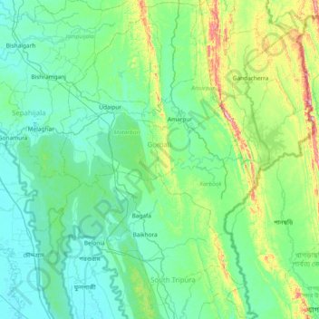
Name: Gomati topographic map, elevation, terrain.
Location: Gomati, Tripura, India (23.08611 91.37438 23.76944 91.84517)
Average elevation: 67 m
Minimum elevation: 4 m
Maximum elevation: 385 m
Topographically, the Gomati district is marked by lush green and fertile Gomati valleys. The towering Debtamura hill range which straddles Udaipur and Amarpur subdivisions of the district with its exquisite sculptural works carved on panels of the hills.
Other topographic maps
Click on a map to view its topography, its elevation and its terrain.
Gachirampara
Gachirampara, Dasda, North Tripura, Tripura, 799271, India
Average elevation: 93 m
Dharmanagar
Dharmanagar, Panisagar, North Tripura, Tripura, 799250, India
Average elevation: 33 m
Kamalpur
India > Tripura > Durga Chowmuhani
Kamalpur, Durga Chowmuhani, Dhalai, Tripura, 799285, India
Average elevation: 47 m
Arundhauti Nagar Children Park
India > Tripura > Dukli > Agartala
Arundhauti Nagar Children Park, Badharghat, Agartala, Dukli, West Tripura, Tripura, 799003, India
Average elevation: 18 m
Sonamura
India > Tripura > Melaghar Urban
Sonamura, Melaghar Urban, Sepahijala, Tripura, India
Average elevation: 21 m
Kailashahar
Kailashahar, Gournagar, Unokoti, Tripura, 799277, India
Average elevation: 33 m
Dumboor Lake
India > Tripura > Raishyabari > Raishyabari
Dumboor Lake, Raishyabari, Dhalai District, Tripura, India
Average elevation: 108 m
Gumti WLS
India > Tripura > Ganganagar
Gumti WLS, Ganganagar, Dhalai, Tripura, India
Average elevation: 109 m