
Make a donation
Gear up for your next adventure:
As an Amazon Associate, this site earns from qualifying purchases at no extra cost to you.
Neustadt topographic map
Click on the map to display elevation.
Make a donation
Gear up for your next adventure:
As an Amazon Associate, this site earns from qualifying purchases at no extra cost to you.
Neustadt
Hier steht mit einer Gesamthöhe von über 50 m und einem Durchmesser von rund 13 m der größte Fachwerkrundbau der Welt, der Junker-Hansen-Turm. Er ist ein eigentlich als Turm der Stadtmauer gebautes Befestigungswerk, das 1480 vom Festungsbaumeister Hans Jakob von Ettlingen über den 1470 abgebrochenen Resten der alten Burg erbaut, dann jedoch als Wohnturm vollendet und in die Anlage des Schlosses Dörnberg integriert worden ist. Das alte Rathaus entstand in den 1550er Jahren.
Make a donation
Gear up for your next adventure:
As an Amazon Associate, this site earns from qualifying purchases at no extra cost to you.
About this map
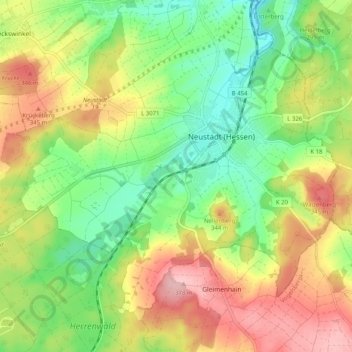
Name: Neustadt topographic map, elevation, terrain.
Average elevation: 295 m
Minimum elevation: 228 m
Maximum elevation: 381 m
Make a donation
Gear up for your next adventure:
As an Amazon Associate, this site earns from qualifying purchases at no extra cost to you.
Other topographic maps
Click on a map to view its topography, its elevation and its terrain.
Neustadt (Hessen)
Deutschland > Hessen > Landkreis Marburg-Biedenkopf > Neustadt
Average elevation: 292 m