
La Rothlach topographic map
Interactive map
Click on the map to display elevation.
About this map
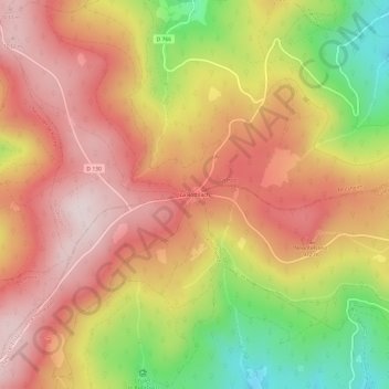
Name: La Rothlach topographic map, elevation, terrain.
Average elevation: 870 m
Minimum elevation: 607 m
Maximum elevation: 1,048 m
Other topographic maps
Click on a map to view its topography, its elevation and its terrain.
Le Hohwald
France > Grand Est > Bas-Rhin > Le Hohwald
Le Hohwald, Sélestat-Erstein, Bas-Rhin, Grand Est, France métropolitaine, 67140, France
Average elevation: 730 m