
Make a donation
Gear up for your next adventure:
As an Amazon Associate, this site earns from qualifying purchases at no extra cost to you.
Pfalzdorf topographic map
Click on the map to display elevation.
Make a donation
Gear up for your next adventure:
As an Amazon Associate, this site earns from qualifying purchases at no extra cost to you.
Pfalzdorf
Pfalzdorf liegt links des Rheins im niederrheinischen Tiefland zwischen Goch, Kalkar und Kleve auf den Pfalzdorfer Höhen, einem Teil des Niederrheinischen Höhenzugs. Benachbarte Orte sind Bedburg-Hau im Norden, Louisendorf im Nordosten, Keppeln im Osten, Goch im Süden, Asperden im Südwesten und Nierswalde im Westen.
Make a donation
Gear up for your next adventure:
As an Amazon Associate, this site earns from qualifying purchases at no extra cost to you.
About this map
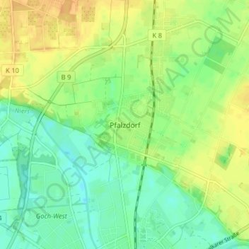
Name: Pfalzdorf topographic map, elevation, terrain.
Average elevation: 25 m
Minimum elevation: 11 m
Maximum elevation: 41 m
Make a donation
Gear up for your next adventure:
As an Amazon Associate, this site earns from qualifying purchases at no extra cost to you.