Geolocate

Gemeinde Seefeld in Tirol topographic map

Interactive map

Click on the map to display elevation.

About this map

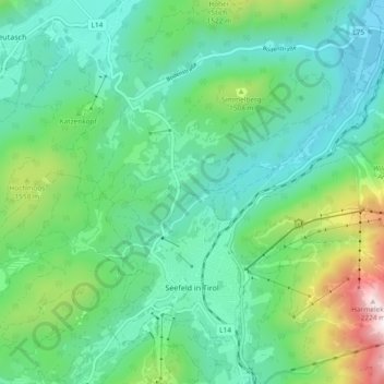
Name: Gemeinde Seefeld in Tirol topographic map, elevation, terrain.

Location: Gemeinde Seefeld in Tirol, Bezirk Innsbruck-Land, Tyrol, 6100, Austria (47.31939 11.16352 47.37000 11.25692)

Average elevation: 1,303 m

Minimum elevation: 1,004 m

Maximum elevation: 2,236 m

Other topographic maps

Click on a map to view its topography, its elevation and its terrain.

Gemeinde Pfaffenhofen

Austria > Tyrol > Bezirk Innsbruck-Land

Gemeinde Pfaffenhofen, Bezirk Innsbruck-Land, Tyrol, 6405, Austria

Average elevation: 1,324 m