
Make a donation
Gear up for your next adventure:
As an Amazon Associate, this site earns from qualifying purchases at no extra cost to you.
Millers topographic map
Click on the map to display elevation.
Make a donation
Gear up for your next adventure:
As an Amazon Associate, this site earns from qualifying purchases at no extra cost to you.
About this map
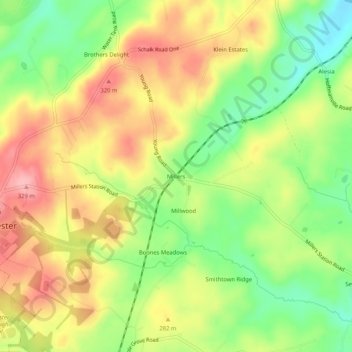
Name: Millers topographic map, elevation, terrain.
Location: Millers, Carroll County, Maryland, 21102, United States (39.65121 -76.87109 39.69121 -76.83109)
Average elevation: 266 m
Minimum elevation: 199 m
Maximum elevation: 331 m
Make a donation
Gear up for your next adventure:
As an Amazon Associate, this site earns from qualifying purchases at no extra cost to you.
Other topographic maps
Click on a map to view its topography, its elevation and its terrain.
Avondale Wildlife Management Area
United States > Maryland > Carroll County > Chapel Heights
Average elevation: 206 m
Make a donation
Gear up for your next adventure:
As an Amazon Associate, this site earns from qualifying purchases at no extra cost to you.