
Make a donation
Gear up for your next adventure:
As an Amazon Associate, this site earns from qualifying purchases at no extra cost to you.
La Reculaz topographic map
Click on the map to display elevation.
Make a donation
Gear up for your next adventure:
As an Amazon Associate, this site earns from qualifying purchases at no extra cost to you.
About this map
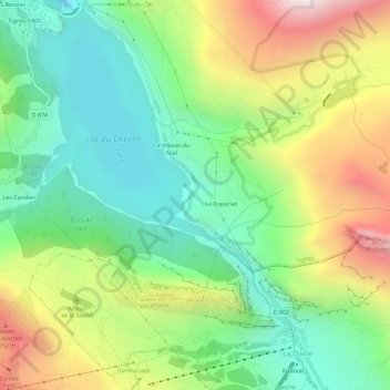
Name: La Reculaz topographic map, elevation, terrain.
Average elevation: 2,116 m
Minimum elevation: 1,640 m
Maximum elevation: 2,916 m
Make a donation
Gear up for your next adventure:
As an Amazon Associate, this site earns from qualifying purchases at no extra cost to you.
Other topographic maps
Click on a map to view its topography, its elevation and its terrain.
Adduction EDF du Nant
France > Auvergne-Rhône-Alpes > Savoie > Tignes > Les Maisonnettes
Average elevation: 1,959 m
Make a donation
Gear up for your next adventure:
As an Amazon Associate, this site earns from qualifying purchases at no extra cost to you.
Refuge du Palet
France > Auvergne-Rhône-Alpes > Savoie > Tignes > Val-Claret
Average elevation: 2,585 m
Barrage du Chevril
France > Auvergne-Rhône-Alpes > Savoie > Tignes > Le Chevril
Average elevation: 1,966 m