
Thank you for supporting this site ❤️
Make a donation
Make a donation
Gear up for your next adventure:
As an Amazon Associate, this site earns from qualifying purchases at no extra cost to you.
Souris topographic map
Click on the map to display elevation.
Thank you for supporting this site ❤️
Make a donation
Make a donation
Gear up for your next adventure:
As an Amazon Associate, this site earns from qualifying purchases at no extra cost to you.
About this map
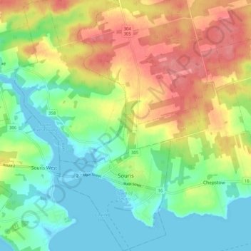
Name: Souris topographic map, elevation, terrain.
Location: Souris, Kings County, Prince Edward Island, C0A 2B0, Canada (46.33544 -62.29540 46.40542 -62.22013)
Average elevation: 33 m
Minimum elevation: -3 m
Maximum elevation: 79 m
Thank you for supporting this site ❤️
Make a donation
Make a donation
Gear up for your next adventure:
As an Amazon Associate, this site earns from qualifying purchases at no extra cost to you.
Other topographic maps
Click on a map to view its topography, its elevation and its terrain.
Prince Edward Island National Park
Canada > Prince Edward Island > Kings County > Greenwich
Average elevation: 2 m