
Make a donation
Gear up for your next adventure:
As an Amazon Associate, this site earns from qualifying purchases at no extra cost to you.
Undingen topographic map
Click on the map to display elevation.
Make a donation
Gear up for your next adventure:
As an Amazon Associate, this site earns from qualifying purchases at no extra cost to you.
Undingen
Das Naturschutzgebiet Ruchberg liegt westlich von Willmandingen. Südwestlich von Erpfingen beginnt das Landschaftsschutzgebiet Laucherttal mit Nebentälern. Mit den Gebieten Salmendingen/Sonnenbühl, Albtrauf zwischen Mössingen und Gönningen und Albtrauf Pfullingen hat die Gemeinde Anteil an drei FFH-Gebieten. Das Vogelschutzgebiet Mittlere Schwäbische Alb erstreckt sich entlang der nördlichen Gemeindegrenze von der Höhe Talheim bis zur Grenze nach Engstingen.
Make a donation
Gear up for your next adventure:
As an Amazon Associate, this site earns from qualifying purchases at no extra cost to you.
About this map
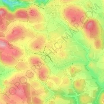
Name: Undingen topographic map, elevation, terrain.
Average elevation: 787 m
Minimum elevation: 687 m
Maximum elevation: 856 m
Make a donation
Gear up for your next adventure:
As an Amazon Associate, this site earns from qualifying purchases at no extra cost to you.
Other topographic maps
Click on a map to view its topography, its elevation and its terrain.
Waldsiedlung Beerenhalde
Deutschland > Baden-Württemberg > Landkreis Reutlingen > Sonnenbühl
Average elevation: 773 m