
Make a donation
Gear up for your next adventure:
As an Amazon Associate, this site earns from qualifying purchases at no extra cost to you.
Wiesenaue topographic map
Click on the map to display elevation.
Make a donation
Gear up for your next adventure:
As an Amazon Associate, this site earns from qualifying purchases at no extra cost to you.
Wiesenaue
Wiesenaue liegt zentral zwischen den Städten Rathenow, Nauen, Kyritz und Neuruppin, nahe Friesack in den Niederungen südlich des Alten Rhin. Westlich der Gemeinde befindet sich der bis zu 77 Meter NHN hohe Höhenrücken Ländchen Friesack und südlich der Große Havelländische Hauptkanal. Das Gemeindegebiet hat Anteil am Wald Zootzen.
Make a donation
Gear up for your next adventure:
As an Amazon Associate, this site earns from qualifying purchases at no extra cost to you.
About this map
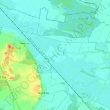
Name: Wiesenaue topographic map, elevation, terrain.
Location: Wiesenaue, Friesack, Havelland, Brandenburg, Deutschland (52.68274 12.60122 52.75590 12.74098)
Average elevation: 33 m
Minimum elevation: 26 m
Maximum elevation: 70 m
Make a donation
Gear up for your next adventure:
As an Amazon Associate, this site earns from qualifying purchases at no extra cost to you.