
Make a donation
Gear up for your next adventure:
As an Amazon Associate, this site earns from qualifying purchases at no extra cost to you.
Aljmaš topographic map
Click on the map to display elevation.
Make a donation
Gear up for your next adventure:
As an Amazon Associate, this site earns from qualifying purchases at no extra cost to you.
About this map
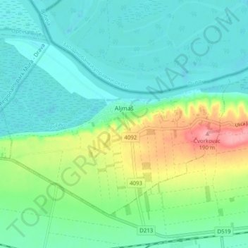
Name: Aljmaš topographic map, elevation, terrain.
Location: Aljmaš, Općina Erdut, Osijek-Baranja County, 31205, Croatia (45.50588 18.90552 45.54565 18.98267)
Average elevation: 106 m
Minimum elevation: 78 m
Maximum elevation: 187 m
Make a donation
Gear up for your next adventure:
As an Amazon Associate, this site earns from qualifying purchases at no extra cost to you.
Other topographic maps
Click on a map to view its topography, its elevation and its terrain.
Osijek
Croatia > Osijek-Baranja County > Osijek
Osijek (Croatian pronunciation: (listen)) is the fourth largest city in Croatia with a population of 108,048 in 2011. It is the largest city and the economic and cultural centre of the eastern Croatian region of Slavonia, as well as the administrative centre of Osijek-Baranja County. Osijek is located on the…
Average elevation: 87 m
Make a donation
Gear up for your next adventure:
As an Amazon Associate, this site earns from qualifying purchases at no extra cost to you.