
Bușteni topographic map
Interactive map
Click on the map to display elevation.
About this map
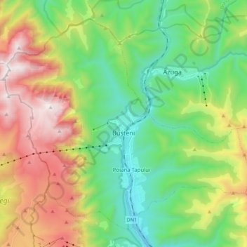
Name: Bușteni topographic map, elevation, terrain.
Location: Bușteni, Prahova, Romania (45.36783 25.45256 45.47040 25.62365)
Average elevation: 1,419 m
Minimum elevation: 807 m
Maximum elevation: 2,500 m
Bușteni (Romanian pronunciation: [buʃˈtenʲ]) is a small mountain town in the north of Prahova County, Muntenia, Romania. It is located in the Prahova Valley, at the bottom of the Bucegi Mountains, that have a maximum altitude of 2,505 m (8,219 ft). Its name literally means tree-logs in Romanian. One village, Poiana Țapului, is administratively part of the town, formerly a separate commune prior to 1950. According to the 2011 census, it has 8,894 inhabitants.
Other topographic maps
Click on a map to view its topography, its elevation and its terrain.