
Thank you for supporting this site ❤️
Make a donation
Make a donation
Gear up for your next adventure:
As an Amazon Associate, this site earns from qualifying purchases at no extra cost to you.
Pas-de-Calais topographic map
Click on the map to display elevation.
Thank you for supporting this site ❤️
Make a donation
Make a donation
Gear up for your next adventure:
As an Amazon Associate, this site earns from qualifying purchases at no extra cost to you.
About this map
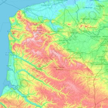
Name: Pas-de-Calais topographic map, elevation, terrain.
Location: Pas-de-Calais, Hauts-de-France, Metropolitan France, France (50.01985 1.55562 51.00882 3.18813)
Average elevation: 61 m
Minimum elevation: -3 m
Maximum elevation: 213 m
Thank you for supporting this site ❤️
Make a donation
Make a donation
Gear up for your next adventure:
As an Amazon Associate, this site earns from qualifying purchases at no extra cost to you.