
Kelsall topographic map
Interactive map
Click on the map to display elevation.
About this map
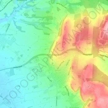
Name: Kelsall topographic map, elevation, terrain.
Location: Kelsall, Cheshire West and Chester, England, United Kingdom (53.19655 -2.75232 53.23044 -2.69301)
Average elevation: 85 m
Minimum elevation: 26 m
Maximum elevation: 177 m
Other topographic maps
Click on a map to view its topography, its elevation and its terrain.
Ness
United Kingdom > England > Cheshire West and Chester > Neston
Ness, Neston, Cheshire West and Chester, England, CH64 4AX, United Kingdom
Average elevation: 34 m
Tarporley
United Kingdom > England > Cheshire West and Chester
Tarporley, Cheshire West and Chester, England, United Kingdom
Average elevation: 85 m
Waverton
United Kingdom > England > Cheshire West and Chester
Waverton, Cheshire West and Chester, England, United Kingdom
Average elevation: 33 m
Childer Thornton
United Kingdom > England > Cheshire West and Chester
Childer Thornton, Ellesmere Port, Cheshire West and Chester, England, CH66 1QZ, United Kingdom
Average elevation: 31 m
Kingswood Park
United Kingdom > England > Cheshire West and Chester > Manley > Kingswood Park
Kingswood Park, Manley, Cheshire West and Chester, North West England, England, United Kingdom
Average elevation: 114 m
Chester
United Kingdom > England > Cheshire West and Chester
Chester, Cheshire West and Chester, England, CH1 2ET, United Kingdom
Average elevation: 61 m
Chidlow
United Kingdom > England > Cheshire West and Chester
Chidlow, Cheshire West and Chester, England, SY14 7JN, United Kingdom
Average elevation: 87 m