
Thank you for supporting this site ❤️
Make a donation
Make a donation
Gear up for your next adventure:
As an Amazon Associate, this site earns from qualifying purchases at no extra cost to you.
Heufeld topographic map
Click on the map to display elevation.
Thank you for supporting this site ❤️
Make a donation
Make a donation
Gear up for your next adventure:
As an Amazon Associate, this site earns from qualifying purchases at no extra cost to you.
Heufeld
Heufeld ist ein Gemeindeteil des Marktes Bruckmühl im Landkreis Rosenheim in Oberbayern. Der Gemeindeteil ist mit den Jahren komplett mit dem Gemeindeteil Bruckmühl zusammengewachsen und liegt auf einer Höhe von 492 m ü. NN.
Thank you for supporting this site ❤️
Make a donation
Make a donation
Gear up for your next adventure:
As an Amazon Associate, this site earns from qualifying purchases at no extra cost to you.
About this map
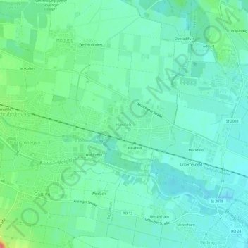
Name: Heufeld topographic map, elevation, terrain.
Average elevation: 493 m
Minimum elevation: 477 m
Maximum elevation: 542 m
Thank you for supporting this site ❤️
Make a donation
Make a donation
Gear up for your next adventure:
As an Amazon Associate, this site earns from qualifying purchases at no extra cost to you.