
Arunachal Pradesh topographic map
Interactive map
Click on the map to display elevation.
Arunachal Pradesh
The climate of Arunachal Pradesh varies with elevation. The low-altitude areas have a Humid subtropical climate. High-altitude areas (3500–5500 m) have a subtropical highland climate and alpine climate. Arunachal Pradesh receives 2,000 to 5,000 millimetres (79 to 197 in) of rainfall annually, 70%–80% obtained between May and October.
About this map
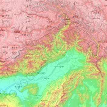
Name: Arunachal Pradesh topographic map, elevation, terrain.
Location: Arunachal Pradesh, India (26.65086 91.56231 29.38238 97.39556)
Average elevation: 2,432 m
Minimum elevation: 44 m
Maximum elevation: 7,048 m
Other topographic maps
Click on a map to view its topography, its elevation and its terrain.
Tawang
India > Arunachal Pradesh > Tawang Circle
India occupied Tawang in 1951 and removed Tibetan administration from the area. China continues to claim Tawang as its region. It is situated 448 km north-west of state capital Itanagar at an elevation of approximately 3,048 metres (10,000 ft). It lies to the north of the Tawang Chu river valley, roughly 10…
Average elevation: 3,280 m