
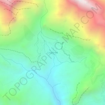
Lingshed topographic map
Interactive map
Click on the map to display elevation.
About this map
Name: Lingshed topographic map, elevation, terrain.
Location: Lingshed, Khalsi tehsil, Leh District, Ladakh, India (33.88384 76.80465 33.92384 76.84465)
Average elevation: 4,209 m
Minimum elevation: 3,574 m
Maximum elevation: 5,487 m
Other topographic maps
Click on a map to view its topography, its elevation and its terrain.
Ursi
India > Ladakh > Khalsi tehsil
Ursi, Khalsi tehsil, Leh District, Ladakh, India
Average elevation: 3,941 m
Debring
India > Ladakh > Khalsi tehsil
Debring, Khalsi tehsil, Leh District, Ladakh, India
Average elevation: 4,380 m
Lamayuru
India > Ladakh > Khalsi tehsil
Lamayuru, Khalsi tehsil, Leh district, Ladakh, India
Average elevation: 3,691 m
Yulchung
India > Ladakh > Khalsi tehsil
Yulchung, Khalsi tehsil, Leh district, Ladakh, India
Average elevation: 4,224 m