
Make a donation
Gear up for your next adventure:
As an Amazon Associate, this site earns from qualifying purchases at no extra cost to you.
Moroto topographic map
Click on the map to display elevation.
Make a donation
Gear up for your next adventure:
As an Amazon Associate, this site earns from qualifying purchases at no extra cost to you.
Moroto
Moroto is located approximately 528 kilometres (328 mi), by road, northeast of Kampala, the capital and largest city of Uganda. The geographical coordinates of Moroto Town are 2°31'48.0"N, 34°40'12.0"E (Latitude:2.5300; Longitude:34.6700). Moroto sits at an average elevation of 1,370 metres (4,490 ft) above mean sea level.
Make a donation
Gear up for your next adventure:
As an Amazon Associate, this site earns from qualifying purchases at no extra cost to you.
About this map
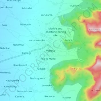
Name: Moroto topographic map, elevation, terrain.
Location: Moroto, Northern Region, Uganda (2.48862 34.61873 2.56862 34.69873)
Average elevation: 1,429 m
Minimum elevation: 1,274 m
Maximum elevation: 2,103 m
Make a donation
Gear up for your next adventure:
As an Amazon Associate, this site earns from qualifying purchases at no extra cost to you.