
Make a donation
Gear up for your next adventure:
As an Amazon Associate, this site earns from qualifying purchases at no extra cost to you.
Atalaia do Norte topographic map
Click on the map to display elevation.
Make a donation
Gear up for your next adventure:
As an Amazon Associate, this site earns from qualifying purchases at no extra cost to you.
About this map
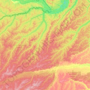
Name: Atalaia do Norte topographic map, elevation, terrain.
Average elevation: 135 m
Minimum elevation: 53 m
Maximum elevation: 264 m
Make a donation
Gear up for your next adventure:
As an Amazon Associate, this site earns from qualifying purchases at no extra cost to you.
Other topographic maps
Click on a map to view its topography, its elevation and its terrain.
Juami River
Juami River is a black water river, a tributary of the white water Japurá River, and runs through the Amazon plain. The entire basin of the Juami River is contained within the Juami-Japurá Ecological Station. The basin has altitudes that range from 45 to 450 metres (148 to 1,476 ft) above sea level.
Average elevation: 109 m