
Make a donation
Gear up for your next adventure:
As an Amazon Associate, this site earns from qualifying purchases at no extra cost to you.
San Bruno topographic map
Click on the map to display elevation.
Make a donation
Gear up for your next adventure:
As an Amazon Associate, this site earns from qualifying purchases at no extra cost to you.
San Bruno
According to the United States Census Bureau, the city has a total area of 5.5 square miles (14 km2), all of it land. The city spreads from the mostly flat lowlands near San Francisco Bay into the foothills of the Santa Cruz Mountains, which rise to more than 600 feet (180 m) above sea level in Crestmoor and more than 700 feet (210 m) above sea level in Portola Highlands. San Bruno City Hall sits at an official elevation of 41 feet (12.5 m) above sea level.
Make a donation
Gear up for your next adventure:
As an Amazon Associate, this site earns from qualifying purchases at no extra cost to you.
About this map
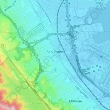
Name: San Bruno topographic map, elevation, terrain.
Average elevation: 106 m
Minimum elevation: -2 m
Maximum elevation: 376 m
Make a donation
Gear up for your next adventure:
As an Amazon Associate, this site earns from qualifying purchases at no extra cost to you.
Other topographic maps
Click on a map to view its topography, its elevation and its terrain.