
Alsace topographic map
Interactive map
Click on the map to display elevation.
Alsace
Alsace has a semi-continental climate at low altitude and a continental climate at high altitude. There is fairly low precipitation because the Vosges protect it from the west. The city of Colmar has a sunny microclimate; it is the second driest city in France, with an annual precipitation of 600 mm, making it ideal for vin d'Alsace (Alsatian wine).
About this map
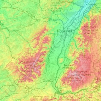
Name: Alsace topographic map, elevation, terrain.
Location: Alsace, Metropolitan France, France (47.42034 6.84132 49.07779 8.23285)
Average elevation: 414 m
Minimum elevation: 100 m
Maximum elevation: 1,471 m
Other topographic maps
Click on a map to view its topography, its elevation and its terrain.
Ruines du Barrage de Malpasset
France > Provence-Alpes-Côte d'Azur > Var > Fréjus
Average elevation: 118 m
Curebouteille
France > Nouvelle-Aquitaine > Haute-Vienne > Oradour-sur-Vayres
Average elevation: 312 m
Mont Ventoux
France > Provence-Alpes-Côte d'Azur > Vaucluse > Saint-Léger-du-Ventoux
There are two small ski stations on the mountain: "Mont Serein" on the north side, and "Chalet Reynard" on the south. High winds and the modest elevation tend to limit the ski season. Weather conditions are such that the northern slope is often icy, leading to a saying among people of the surrounding region…
Average elevation: 1,557 m
Argentière
France > Auvergne-Rhône-Alpes > Upper Savoy > Chamonix-Mont-Blanc
Argentière (French pronunciation: [aʁʒɑ̃tjɛʁ]) is a picturesque skiing, alpine walking and mountaineering village in the French Alps, part of the commune of Chamonix-Mont-Blanc, at an altitude of 1,252 m (4,108 ft).
Average elevation: 1,674 m
Les Ravineaux
France > Centre-Val de Loire > Indre > Villentrois-Faverolles-en-Berry
Average elevation: 131 m
Le Tilleul - Antifer
France > Normandy > Seine-Maritime > La Poterie-Cap-d'Antifer
Average elevation: 42 m
Méribel-Mottaret
France > Auvergne-Rhône-Alpes > Savoy > Les Allues > Méribel-Mottaret
Average elevation: 2,012 m
Collonges
France > Auvergne-Rhône-Alpes > Upper Savoy > Vétraz-Monthoux > Collonges
Average elevation: 477 m
Les Ansaults
France > Centre-Loire Valley > Indre-et-Loire > Artannes-sur-Indre > Les Ansaults
Average elevation: 73 m
Les Clausonnes
France > Provence-Alpes-Côte d'Azur > Maritime Alps > Valbonne > Les Clausonnes
Average elevation: 149 m