
Make a donation
Gear up for your next adventure:
As an Amazon Associate, this site earns from qualifying purchases at no extra cost to you.
Altena topographic map
Click on the map to display elevation.
Make a donation
Gear up for your next adventure:
As an Amazon Associate, this site earns from qualifying purchases at no extra cost to you.
About this map
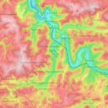
Name: Altena topographic map, elevation, terrain.
Location: Altena, Märkischer Kreis, North Rhine-Westphalia, 58762, Germany (51.23865 7.63168 51.31815 7.76803)
Average elevation: 347 m
Minimum elevation: 141 m
Maximum elevation: 509 m
Make a donation
Gear up for your next adventure:
As an Amazon Associate, this site earns from qualifying purchases at no extra cost to you.
Other topographic maps
Click on a map to view its topography, its elevation and its terrain.
Rotthausen
Germany > North Rhine-Westphalia > Märkischer Kreis > Schalksmühle
Average elevation: 343 m
Gelstern
Germany > North Rhine-Westphalia > Märkischer Kreis > Schalksmühle > Heedfeld
Average elevation: 385 m
Moßberg
Germany > North Rhine-Westphalia > Märkischer Kreis > Menden (Sauerland)
Average elevation: 220 m
Make a donation
Gear up for your next adventure:
As an Amazon Associate, this site earns from qualifying purchases at no extra cost to you.
Blechen
Germany > North Rhine-Westphalia > Märkischer Kreis > Kierspe > Blechen
Average elevation: 376 m