
Make a donation
Gear up for your next adventure:
As an Amazon Associate, this site earns from qualifying purchases at no extra cost to you.
Noailhac topographic map
Click on the map to display elevation.
Make a donation
Gear up for your next adventure:
As an Amazon Associate, this site earns from qualifying purchases at no extra cost to you.
About this map
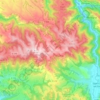
Name: Noailhac topographic map, elevation, terrain.
Average elevation: 435 m
Minimum elevation: 221 m
Maximum elevation: 639 m
Make a donation
Gear up for your next adventure:
As an Amazon Associate, this site earns from qualifying purchases at no extra cost to you.
Other topographic maps
Click on a map to view its topography, its elevation and its terrain.
Falguières
France > Occitanie > Aveyron > Conques-en-Rouergue > Saint-Cyprien-sur-Dourdou
Average elevation: 396 m
La Boutique
France > Occitanie > Aveyron > Conques-en-Rouergue > Saint-Cyprien-sur-Dourdou
Average elevation: 381 m
Le Pouget
France > Occitanie > Aveyron > Conques-en-Rouergue > Saint-Cyprien-sur-Dourdou
Average elevation: 348 m
Make a donation
Gear up for your next adventure:
As an Amazon Associate, this site earns from qualifying purchases at no extra cost to you.
La Paraquie
France > Occitanie > Aveyron > Conques-en-Rouergue > Saint-Cyprien-sur-Dourdou
Average elevation: 351 m
Conques Faubourg
France > Occitanie > Aveyron > Conques-en-Rouergue > Conques
Average elevation: 429 m
Make a donation
Gear up for your next adventure:
As an Amazon Associate, this site earns from qualifying purchases at no extra cost to you.
La Combe del Ly
France > Occitanie > Aveyron > Conques-en-Rouergue > Saint-Cyprien-sur-Dourdou > La Combe del Ly
Average elevation: 357 m
Make a donation
Gear up for your next adventure:
As an Amazon Associate, this site earns from qualifying purchases at no extra cost to you.