
Waterfront Park topographic map
Interactive map
Click on the map to display elevation.
About this map
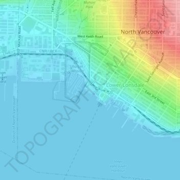
Name: Waterfront Park topographic map, elevation, terrain.
Average elevation: 22 m
Minimum elevation: 0 m
Maximum elevation: 118 m
Other topographic maps
Click on a map to view its topography, its elevation and its terrain.
Mahon Park
Canada > British Columbia > Metro Vancouver Regional District > North Vancouver
Mahon Park, Marine-Hamilton, Lower Lonsdale, North Vancouver, Metro Vancouver Regional District, British Columbia, V7M, Canada
Average elevation: 65 m
North Vancouver
Canada > British Columbia > Metro Vancouver Regional District > North Vancouver
North Vancouver, District of North Vancouver, Metro Vancouver Regional District, British Columbia, Canada
Average elevation: 591 m