
Make a donation
Gear up for your next adventure:
As an Amazon Associate, this site earns from qualifying purchases at no extra cost to you.
Altona topographic map
Click on the map to display elevation.
Make a donation
Gear up for your next adventure:
As an Amazon Associate, this site earns from qualifying purchases at no extra cost to you.
Altona
The hamlet of Altona is located in the northern part of the town of Altona at 44°53′24″N 73°39′9″W / 44.89000°N 73.65250°W / 44.89000; -73.65250 (44.890096, -73.65272). The Great Chazy River flows along the southeastern edge of the hamlet, dropping 150 feet (46 m) in elevation in 1.7 miles (2.7 km). The Ganienkeh Community of the Mohawk people is southwest of the hamlet.
Make a donation
Gear up for your next adventure:
As an Amazon Associate, this site earns from qualifying purchases at no extra cost to you.
About this map
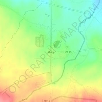
Name: Altona topographic map, elevation, terrain.
Average elevation: 196 m
Minimum elevation: 157 m
Maximum elevation: 243 m
Make a donation
Gear up for your next adventure:
As an Amazon Associate, this site earns from qualifying purchases at no extra cost to you.