
Make a donation
Gear up for your next adventure:
As an Amazon Associate, this site earns from qualifying purchases at no extra cost to you.
Agassiz topographic map
Click on the map to display elevation.
Make a donation
Gear up for your next adventure:
As an Amazon Associate, this site earns from qualifying purchases at no extra cost to you.
About this map
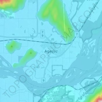
Name: Agassiz topographic map, elevation, terrain.
Average elevation: 48 m
Minimum elevation: 10 m
Maximum elevation: 1,001 m
Make a donation
Gear up for your next adventure:
As an Amazon Associate, this site earns from qualifying purchases at no extra cost to you.
Other topographic maps
Click on a map to view its topography, its elevation and its terrain.
Campbell Lake
Canada > British Columbia > Fraser Valley Regional District > Kent
Average elevation: 528 m
Hicks Lake
Canada > British Columbia > Fraser Valley Regional District > Kent
Average elevation: 377 m
Harrison River
Canada > British Columbia > Fraser Valley Regional District > Kent > Harrison Mills
Average elevation: 45 m