
Make a donation
Gear up for your next adventure:
As an Amazon Associate, this site earns from qualifying purchases at no extra cost to you.
Beqaa Governorate topographic map
Click on the map to display elevation.
Make a donation
Gear up for your next adventure:
As an Amazon Associate, this site earns from qualifying purchases at no extra cost to you.
About this map
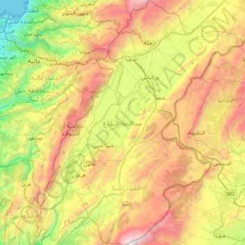
Name: Beqaa Governorate topographic map, elevation, terrain.
Location: Beqaa Governorate, Lebanon (33.41111 35.60756 33.93669 36.13097)
Average elevation: 1,106 m
Minimum elevation: 0 m
Maximum elevation: 2,808 m
Make a donation
Gear up for your next adventure:
As an Amazon Associate, this site earns from qualifying purchases at no extra cost to you.
Other topographic maps
Click on a map to view its topography, its elevation and its terrain.
Arab Salim
Lebanon > Nabatieh Governorate
Arabsalim is located 87 km from Beirut, at an altitude of 700 meters above sea level
Average elevation: 546 m
Make a donation
Gear up for your next adventure:
As an Amazon Associate, this site earns from qualifying purchases at no extra cost to you.