
Make a donation
Gear up for your next adventure:
As an Amazon Associate, this site earns from qualifying purchases at no extra cost to you.
Kerteh topographic map
Click on the map to display elevation.
Make a donation
Gear up for your next adventure:
As an Amazon Associate, this site earns from qualifying purchases at no extra cost to you.
About this map
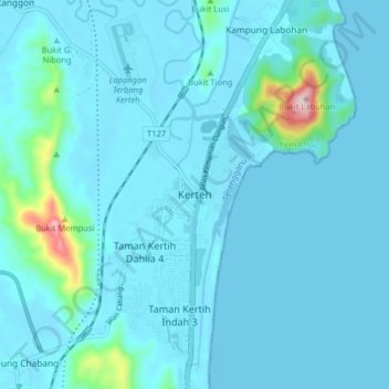
Name: Kerteh topographic map, elevation, terrain.
Location: Kerteh, Kemaman District, Terengganu, 24300, Malaysia (4.46831 103.40180 4.54831 103.48180)
Average elevation: 27 m
Minimum elevation: -4 m
Maximum elevation: 343 m
Make a donation
Gear up for your next adventure:
As an Amazon Associate, this site earns from qualifying purchases at no extra cost to you.
Other topographic maps
Click on a map to view its topography, its elevation and its terrain.
Make a donation
Gear up for your next adventure:
As an Amazon Associate, this site earns from qualifying purchases at no extra cost to you.
Sungai Kandang Rusa
Malaysia > Terengganu > Kemaman District > Kampung Semayor
Average elevation: 32 m