
Make a donation
Gear up for your next adventure:
As an Amazon Associate, this site earns from qualifying purchases at no extra cost to you.
Mirveti topographic map
Click on the map to display elevation.
Make a donation
Gear up for your next adventure:
As an Amazon Associate, this site earns from qualifying purchases at no extra cost to you.
About this map
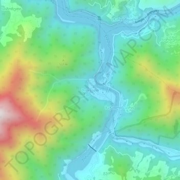
Name: Mirveti topographic map, elevation, terrain.
Average elevation: 314 m
Minimum elevation: 31 m
Maximum elevation: 1,059 m
Make a donation
Gear up for your next adventure:
As an Amazon Associate, this site earns from qualifying purchases at no extra cost to you.
Other topographic maps
Click on a map to view its topography, its elevation and its terrain.
Machakhlistskali
Georgia > Autonomous Republic of Adjara > Khelvachauri Municipality > Machakhlispiri
Average elevation: 777 m
Makhinjauri
Georgia > Autonomous Republic of Adjara > Khelvachauri Municipality
Average elevation: 53 m
Make a donation
Gear up for your next adventure:
As an Amazon Associate, this site earns from qualifying purchases at no extra cost to you.