
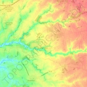
Le Girouard topographic map
Interactive map
Click on the map to display elevation.
About this map
Name: Le Girouard topographic map, elevation, terrain.
Average elevation: 48 m
Minimum elevation: 12 m
Maximum elevation: 74 m
Other topographic maps
Click on a map to view its topography, its elevation and its terrain.
Saint-Michel-en-l'Herm
France > Pays de la Loire > Vendée
Saint-Michel-en-l'Herm, Fontenay-le-Comte, Vendée, Pays de la Loire, Metropolitan France, 85580, France
Average elevation: 1 m
L'Égronnière
France > Pays de la Loire > Vendée > Montaigu-Vendée > Saint-Hilaire-de-Loulay
L'Égronnière, Saint-Hilaire-de-Loulay, Montaigu-Vendée, La Roche-sur-Yon, Vendée, Pays de la Loire, Metropolitan France, 85600, France
Average elevation: 42 m
Saint-Hilaire-la-Forêt
France > Pays de la Loire > Vendée
Saint-Hilaire-la-Forêt, Les Sables-d'Olonne, Vendée, Pays de la Loire, Metropolitan France, 85440, France
Average elevation: 20 m
Gloriet
France > Pays de la Loire > Vendée > Les Sables-d'Olonne
Gloriet, Olonne-sur-Mer, Les Sables-d'Olonne, Vendée, Pays de la Loire, Metropolitan France, 85340, France
Average elevation: 11 m
Logis Du Fenestreau
France > Pays de la Loire > Vendée > Les Sables-d'Olonne > Les Soulardières
Logis Du Fenestreau, Rue du Bois, Les Soulardières, Château-d'Olonne, Les Sables-d'Olonne, Vendée, Pays de la Loire, Metropolitan France, 85180, France
Average elevation: 31 m
L'Épine
France > Pays de la Loire > Vendée
L'Épine, Les Sables-d'Olonne, Vendée, Pays de la Loire, Metropolitan France, 85740, France
Average elevation: 2 m
La Flocellière
France > Pays de la Loire > Vendée > Sèvremont
La Flocellière, Sèvremont, Fontenay-le-Comte, Vendée, Pays de la Loire, Metropolitan France, 85700, France
Average elevation: 190 m
Les Brouzils
France > Pays de la Loire > Vendée
Les Brouzils, La Roche-sur-Yon, Vendée, Pays de la Loire, Metropolitan France, 85260, France
Average elevation: 64 m
Beugné-l'Abbé
France > Pays de la Loire > Vendée > Les Magnils-Reigniers
Beugné-l'Abbé, Les Magnils-Reigniers, Fontenay-le-Comte, Vendée, Pays de la Loire, Metropolitan France, 85400, France
Average elevation: 7 m
La Haute Garde
France > Pays de la Loire > Vendée > Vouvant
La Haute Garde, Vouvant, Fontenay-le-Comte, Vendée, Pays de la Loire, Metropolitan France, 85120, France
Average elevation: 83 m
L'Orbrie
France > Pays de la Loire > Vendée
L'Orbrie, Fontenay-le-Comte, Vendée, Pays de la Loire, Metropolitan France, 85200, France
Average elevation: 63 m
La Noue
France > Pays de la Loire > Vendée > L'Orbrie
La Noue, L'Orbrie, Fontenay-le-Comte, Vendée, Pays de la Loire, Metropolitan France, 85200, France
Average elevation: 48 m
Boulogne
France > Pays de la Loire > Vendée > Essarts-en-Bocage
Boulogne, Essarts-en-Bocage, La Roche-sur-Yon, Vendée, Pays de la Loire, Metropolitan France, 85140, France
Average elevation: 81 m
Cugand
France > Pays de la Loire > Vendée > Cugand
Cugand, La Roche-sur-Yon, Vendée, Pays de la Loire, Metropolitan France, 85610, France
Average elevation: 49 m
Les Sables-d'Olonne
France > Pays de la Loire > Vendée > Les Sables-d'Olonne
Les Sables-d'Olonne, Vendée, Pays de la Loire, Metropolitan France, 85100, France
Average elevation: 6 m
Saint-Hilaire-de-Riez
France > Pays de la Loire > Vendée
Saint-Hilaire-de-Riez, Les Sables-d'Olonne, Vendée, Pays de la Loire, Metropolitan France, 85270, France
Average elevation: 5 m
Les Herbiers
France > Pays de la Loire > Vendée
Les Herbiers, La Roche-sur-Yon, Vendée, Pays de la Loire, Metropolitan France, 85500, France
Average elevation: 129 m
Bazoges-en-Pareds
France > Pays de la Loire > Vendée
Bazoges-en-Pareds, Fontenay-le-Comte, Vendée, Pays de la Loire, Metropolitan France, 85390, France
Average elevation: 86 m
La Roche-sur-Yon
France > Pays de la Loire > Vendée
La Roche-sur-Yon, Vendée, Pays de la Loire, Metropolitan France, 85000, France
Average elevation: 67 m