
Make a donation
Gear up for your next adventure:
As an Amazon Associate, this site earns from qualifying purchases at no extra cost to you.
Pfänder topographic map
Click on the map to display elevation.
Make a donation
Gear up for your next adventure:
As an Amazon Associate, this site earns from qualifying purchases at no extra cost to you.
Pfänder
Bei klarem Wetter reicht der Vierländer-Blick (Österreich, Deutschland, Schweiz, Liechtenstein) von den Allgäuer und Lechtaler Alpen im Osten über den Bregenzerwald, die steilen Gipfel des Arlberggebietes und der Silvretta, weiter über den Rätikon bis zu den Schweizer Bergen und den Ausläufern des Schwarzwaldes im Westen. Zu seinen Füßen liegt der Bodensee, eingerahmt vom Rheintal und dem oberschwäbischen Hügelland. Der Höhenunterschied vom Bodensee zum Gipfel beträgt 667 Meter.
Make a donation
Gear up for your next adventure:
As an Amazon Associate, this site earns from qualifying purchases at no extra cost to you.
About this map
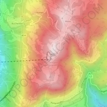
Name: Pfänder topographic map, elevation, terrain.
Location: Pfänder, Lochau, Bezirk Bregenz, Vorarlberg, 6911, Österreich (47.50732 9.78015 47.50742 9.78025)
Average elevation: 826 m
Minimum elevation: 476 m
Maximum elevation: 1,055 m
Make a donation
Gear up for your next adventure:
As an Amazon Associate, this site earns from qualifying purchases at no extra cost to you.
Other topographic maps
Click on a map to view its topography, its elevation and its terrain.