
Make a donation
Gear up for your next adventure:
As an Amazon Associate, this site earns from qualifying purchases at no extra cost to you.
Mwanza topographic map
Click on the map to display elevation.
Make a donation
Gear up for your next adventure:
As an Amazon Associate, this site earns from qualifying purchases at no extra cost to you.
Mwanza
Mwanza features a tropical savanna climate under the Köppen climate classification. Temperatures are relatively consistent throughout the course of the year, tempered by the city's altitude. Thus, the climate is not quite as hot as one might expect, given the city's location near the equator. Average temperatures in Mwanza is roughly 23.5 °C (74.3 °F) throughout the year. The city features a lengthy wet season which runs from October through May and a short pronounced dry season that covers the remaining four months. Mwanza receives on average roughly 1,050 millimetres (41 in) of precipitation annually.
Make a donation
Gear up for your next adventure:
As an Amazon Associate, this site earns from qualifying purchases at no extra cost to you.
About this map
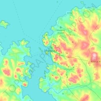
Name: Mwanza topographic map, elevation, terrain.
Location: Mwanza, Nyamagana, Mwanza Region, Lake Zone, 33214, Tanzania (-2.67969 32.74144 -2.35969 33.06144)
Average elevation: 1,178 m
Minimum elevation: 1,129 m
Maximum elevation: 1,346 m
Make a donation
Gear up for your next adventure:
As an Amazon Associate, this site earns from qualifying purchases at no extra cost to you.
Other topographic maps
Click on a map to view its topography, its elevation and its terrain.