
Make a donation
Gear up for your next adventure:
As an Amazon Associate, this site earns from qualifying purchases at no extra cost to you.
Schwerin topographic map
Click on the map to display elevation.
Make a donation
Gear up for your next adventure:
As an Amazon Associate, this site earns from qualifying purchases at no extra cost to you.
About this map
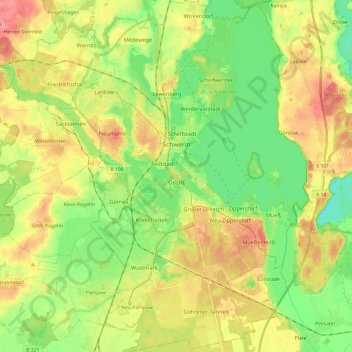
Name: Schwerin topographic map, elevation, terrain.
Location: Schwerin, Mecklenburg-Vorpommern, Germany (53.54436 11.29603 53.68734 11.50554)
Average elevation: 52 m
Minimum elevation: 18 m
Maximum elevation: 93 m
Make a donation
Gear up for your next adventure:
As an Amazon Associate, this site earns from qualifying purchases at no extra cost to you.
Other topographic maps
Click on a map to view its topography, its elevation and its terrain.
Neu-Grambow
Germany > Mecklenburg-Vorpommern > Vorpommern-Greifswald > Grambow
Average elevation: 38 m
Make a donation
Gear up for your next adventure:
As an Amazon Associate, this site earns from qualifying purchases at no extra cost to you.
Heiligendamm
Germany > Mecklenburg-Vorpommern > Landkreis Rostock > Bad Doberan
Average elevation: 8 m
Make a donation
Gear up for your next adventure:
As an Amazon Associate, this site earns from qualifying purchases at no extra cost to you.
Make a donation
Gear up for your next adventure:
As an Amazon Associate, this site earns from qualifying purchases at no extra cost to you.
Riemserort
Germany > Mecklenburg-Vorpommern > Vorpommern-Greifswald > Greifswald
Average elevation: 1 m
Bohnenwerder
Germany > Mecklenburg-Vorpommern > Mecklenburgische Seenplatte > Carwitz
Average elevation: 91 m
Make a donation
Gear up for your next adventure:
As an Amazon Associate, this site earns from qualifying purchases at no extra cost to you.
Valluhn
Germany > Mecklenburg-Vorpommern > Ludwigslust-Parchim > Lüttow-Valluhn
Average elevation: 32 m
Greifswald
Germany > Mecklenburg-Vorpommern > Vorpommern-Greifswald > Greifswald > Greifswald
Average elevation: 6 m
Make a donation
Gear up for your next adventure:
As an Amazon Associate, this site earns from qualifying purchases at no extra cost to you.
Wismar
Germany > Mecklenburg-Vorpommern > Nordwestmecklenburg > Wismar > Wismar
Average elevation: 14 m
Löcknitz
Germany > Mecklenburg-Vorpommern > Vorpommern-Greifswald > Löcknitz > Löcknitz
Average elevation: 13 m
Make a donation
Gear up for your next adventure:
As an Amazon Associate, this site earns from qualifying purchases at no extra cost to you.
Bismark
Germany > Mecklenburg-Vorpommern > Vorpommern-Greifswald > Ramin > Bismark
Average elevation: 36 m