
Make a donation
Gear up for your next adventure:
As an Amazon Associate, this site earns from qualifying purchases at no extra cost to you.
Tropic topographic map
Click on the map to display elevation.
Make a donation
Gear up for your next adventure:
As an Amazon Associate, this site earns from qualifying purchases at no extra cost to you.
About this map
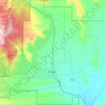
Name: Tropic topographic map, elevation, terrain.
Location: Tropic, Garfield County, Utah, 84776, United States (37.60805 -112.13346 37.66260 -112.06484)
Average elevation: 1,997 m
Minimum elevation: 1,857 m
Maximum elevation: 2,326 m
Make a donation
Gear up for your next adventure:
As an Amazon Associate, this site earns from qualifying purchases at no extra cost to you.
Other topographic maps
Click on a map to view its topography, its elevation and its terrain.
Make a donation
Gear up for your next adventure:
As an Amazon Associate, this site earns from qualifying purchases at no extra cost to you.
Bryce Canyon City
United States > Utah > Garfield County > Bryce Canyon City
Average elevation: 2,337 m
Panguitch
United States > Utah > Garfield County > Panguitch
Panguitch was first settled in March 1864, when Jens Nielsen, a Danish convert to The Church of Jesus Christ of Latter-day Saints, led a group of 54 families eastward from Parowan and Beaver to the Sevier River. Due to the area's high elevation, 6,600 feet (2,000 m) above sea level, winter's cold weather…
Average elevation: 2,081 m
Make a donation
Gear up for your next adventure:
As an Amazon Associate, this site earns from qualifying purchases at no extra cost to you.