
Make a donation
Gear up for your next adventure:
As an Amazon Associate, this site earns from qualifying purchases at no extra cost to you.
Chattanooga topographic map
Click on the map to display elevation.
Make a donation
Gear up for your next adventure:
As an Amazon Associate, this site earns from qualifying purchases at no extra cost to you.
Chattanooga
According to the United States Census Bureau, the city has a total area of 144.6 square miles (374.4 km2), of which 137.1 square miles (355.2 km2) are land and 7.4 square miles (19.2 km2), or 5.12%, are water. The most prominent natural features in and around Chattanooga are the Tennessee River and the surrounding mountains. The Tennessee River is impounded by the Chickamauga Dam north of the downtown area. The city is nestled between the southwestern Ridge-and-valley Appalachians and the foot of Walden's Ridge; the river separates the ridge from the western side of downtown. Several miles east, the city is bisected by Missionary Ridge. The downtown area sits at an elevation of approximately 676 feet (206 m), one of the lowest elevations in East Tennessee.
Make a donation
Gear up for your next adventure:
As an Amazon Associate, this site earns from qualifying purchases at no extra cost to you.
About this map
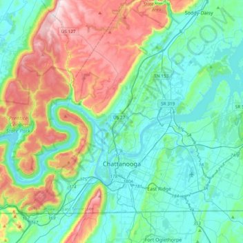
Name: Chattanooga topographic map, elevation, terrain.
Average elevation: 331 m
Minimum elevation: 189 m
Maximum elevation: 722 m
Make a donation
Gear up for your next adventure:
As an Amazon Associate, this site earns from qualifying purchases at no extra cost to you.