
Make a donation
Gear up for your next adventure:
As an Amazon Associate, this site earns from qualifying purchases at no extra cost to you.
Nuremberg topographic map
Click on the map to display elevation.
Make a donation
Gear up for your next adventure:
As an Amazon Associate, this site earns from qualifying purchases at no extra cost to you.
Nuremberg
Nuremberg has an oceanic climate (Köppen Cfb) with a certain humid continental influence (Dfb), categorized in the latter by the 0 °C isotherm. The city's climate is influenced by its inland position and higher altitude. Winters are changeable, with either mild or cold weather: the average temperature is around −3 °C (27 °F) to 4 °C (39 °F), while summers are generally warm, mostly around 13 °C (55 °F) at night to 25 °C (77 °F) in the afternoon. Precipitation is evenly spread throughout the year, although February and April tend to be a bit drier whereas July tends to have more rainfall.
Make a donation
Gear up for your next adventure:
As an Amazon Associate, this site earns from qualifying purchases at no extra cost to you.
About this map
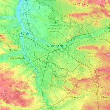
Name: Nuremberg topographic map, elevation, terrain.
Location: Nuremberg, Bavaria, Germany (49.33143 10.98873 49.54075 11.28260)
Average elevation: 336 m
Minimum elevation: 279 m
Maximum elevation: 437 m
Make a donation
Gear up for your next adventure:
As an Amazon Associate, this site earns from qualifying purchases at no extra cost to you.
Other topographic maps
Click on a map to view its topography, its elevation and its terrain.
Make a donation
Gear up for your next adventure:
As an Amazon Associate, this site earns from qualifying purchases at no extra cost to you.