
Make a donation
Gear up for your next adventure:
As an Amazon Associate, this site earns from qualifying purchases at no extra cost to you.
Zim topographic map
Click on the map to display elevation.
Make a donation
Gear up for your next adventure:
As an Amazon Associate, this site earns from qualifying purchases at no extra cost to you.
About this map
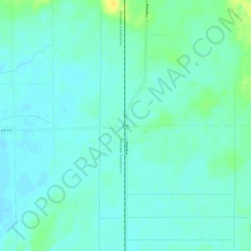
Name: Zim topographic map, elevation, terrain.
Location: Zim, Saint Louis County, Minnesota, United States (47.28688 -92.62324 47.32688 -92.58324)
Average elevation: 408 m
Minimum elevation: 402 m
Maximum elevation: 423 m
Make a donation
Gear up for your next adventure:
As an Amazon Associate, this site earns from qualifying purchases at no extra cost to you.
Other topographic maps
Click on a map to view its topography, its elevation and its terrain.
Duluth
United States > Minnesota > Saint Louis County
Duluth's topography is distinctive, defined by its hilly terrain and its proximity to Lake Superior. The city is perched on an incline rising sharply from the lake, with elevations ranging from lake level at about 600 feet to approximately 1,400 feet at the ridge tops. This steep gradient creates dramatic…
Average elevation: 286 m
Make a donation
Gear up for your next adventure:
As an Amazon Associate, this site earns from qualifying purchases at no extra cost to you.
Chris Lake
United States > Minnesota > Saint Louis County > Pequaywan Township
Average elevation: 494 m
Make a donation
Gear up for your next adventure:
As an Amazon Associate, this site earns from qualifying purchases at no extra cost to you.
West Duluth
United States > Minnesota > Saint Louis County > Duluth
West Duluth covers an area of 5,726 acres (23 km2), or 13% of the city area, making it the third-largest district in the city. Note that, as with many other Duluth neighborhood districts, the area actually developed to a major extent is considerably smaller than the district figure. This is largely due to the…
Average elevation: 252 m
Make a donation
Gear up for your next adventure:
As an Amazon Associate, this site earns from qualifying purchases at no extra cost to you.
Proctor
United States > Minnesota > Saint Louis County
Proctor is adjacent to Duluth's Bayview Heights neighborhood, with which it forms something of a contiguous community unit due to Bayview Heights' topographical separation (the hill) from adjacent West Duluth. It is bounded by the city of Hermantown to the north, Midway Township to the west, Bayview Heights to…
Average elevation: 374 m
Make a donation
Gear up for your next adventure:
As an Amazon Associate, this site earns from qualifying purchases at no extra cost to you.
Make a donation
Gear up for your next adventure:
As an Amazon Associate, this site earns from qualifying purchases at no extra cost to you.
Duluth
United States > Minnesota > Saint Louis County
Duluth's topography is dominated by a steep hillside that climbs from Lake Superior to high inland elevations. Duluth has been called "the San Francisco of the Midwest," alluding to San Francisco's similar water-to-hilltop topography. This similarity was most evident before World War II, when Duluth had a…
Average elevation: 286 m
Duluth
United States > Minnesota > Saint Louis County
Duluth's topography is dominated by a steep hillside that climbs from Lake Superior to high inland elevations. Duluth has been called "the San Francisco of the Midwest," alluding to San Francisco's similar water-to-hilltop topography. This similarity was most evident before World War II, when Duluth had a…
Average elevation: 276 m
Make a donation
Gear up for your next adventure:
As an Amazon Associate, this site earns from qualifying purchases at no extra cost to you.
Make a donation
Gear up for your next adventure:
As an Amazon Associate, this site earns from qualifying purchases at no extra cost to you.
Duluth
United States > Minnesota > Saint Louis County
Duluth's topography is dominated by a steep hillside that climbs from Lake Superior to high inland elevations. Duluth has been called "the San Francisco of the Midwest," alluding to San Francisco's similar water-to-hilltop topography. This similarity was most evident before World War II, when Duluth had a…
Average elevation: 286 m
Echo River
United States > Minnesota > Saint Louis County > Northeast St Louis
Average elevation: 393 m
Make a donation
Gear up for your next adventure:
As an Amazon Associate, this site earns from qualifying purchases at no extra cost to you.
Make a donation
Gear up for your next adventure:
As an Amazon Associate, this site earns from qualifying purchases at no extra cost to you.
Make a donation
Gear up for your next adventure:
As an Amazon Associate, this site earns from qualifying purchases at no extra cost to you.
Make a donation
Gear up for your next adventure:
As an Amazon Associate, this site earns from qualifying purchases at no extra cost to you.
Eagles Nest Lake Number One
United States > Minnesota > Saint Louis County > Eagles Nest Township
Average elevation: 461 m
Duluth
United States > Minnesota > Saint Louis County
Duluth's topography is dominated by a steep hillside that climbs from Lake Superior to high inland elevations. Duluth has been called "the San Francisco of the Midwest", alluding to San Francisco's similar water-to-hilltop topography. This similarity was most evident before World War II, when Duluth had a…
Average elevation: 286 m
Make a donation
Gear up for your next adventure:
As an Amazon Associate, this site earns from qualifying purchases at no extra cost to you.
Duluth
United States > Minnesota > Saint Louis County
Duluth's topography is dominated by a steep hillside that climbs from Lake Superior to high inland elevations. Duluth has been called "the San Francisco of the Midwest", alluding to San Francisco's similar water-to-hilltop topography. This similarity was most evident before World War II, when Duluth had a…
Average elevation: 276 m
Make a donation
Gear up for your next adventure:
As an Amazon Associate, this site earns from qualifying purchases at no extra cost to you.
Make a donation
Gear up for your next adventure:
As an Amazon Associate, this site earns from qualifying purchases at no extra cost to you.
Make a donation
Gear up for your next adventure:
As an Amazon Associate, this site earns from qualifying purchases at no extra cost to you.