
Make a donation
Gear up for your next adventure:
As an Amazon Associate, this site earns from qualifying purchases at no extra cost to you.
Wavell topographic map
Click on the map to display elevation.
Make a donation
Gear up for your next adventure:
As an Amazon Associate, this site earns from qualifying purchases at no extra cost to you.
About this map
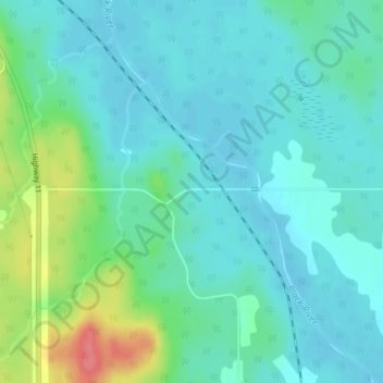
Name: Wavell topographic map, elevation, terrain.
Average elevation: 304 m
Minimum elevation: 288 m
Maximum elevation: 356 m
Make a donation
Gear up for your next adventure:
As an Amazon Associate, this site earns from qualifying purchases at no extra cost to you.
Other topographic maps
Click on a map to view its topography, its elevation and its terrain.
Painkiller Lake
Canada > Ontario > Cochrane District > Black River-Matheson Township
Average elevation: 302 m
Borgford Lake
Canada > Ontario > Cochrane District > Black River-Matheson Township
Average elevation: 346 m
Watabeag River
Canada > Ontario > Cochrane District > Black River-Matheson Township
Average elevation: 261 m
Make a donation
Gear up for your next adventure:
As an Amazon Associate, this site earns from qualifying purchases at no extra cost to you.