
Thank you for supporting this site ❤️
Make a donation
Make a donation
Gear up for your next adventure:
As an Amazon Associate, this site earns from qualifying purchases at no extra cost to you.
Cocachimba topographic map
Click on the map to display elevation.
Thank you for supporting this site ❤️
Make a donation
Make a donation
Gear up for your next adventure:
As an Amazon Associate, this site earns from qualifying purchases at no extra cost to you.
About this map
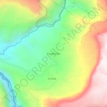
Name: Cocachimba topographic map, elevation, terrain.
Location: Cocachimba, Valera, Bongará, Amazonas, Perú (-6.07811 -77.91497 -6.03811 -77.87497)
Average elevation: 1,970 m
Minimum elevation: 1,425 m
Maximum elevation: 2,671 m
Thank you for supporting this site ❤️
Make a donation
Make a donation
Gear up for your next adventure:
As an Amazon Associate, this site earns from qualifying purchases at no extra cost to you.